
Heilbronn way

The Heilbronner Weg is a high alpine hiking trail in the Allgäu Alps . It is part of the connecting path from the Rappenseehütte to the Waltenbergerhaus or to the Kemptner Hütte at an altitude of 2432 m to 2615 m . It has a length of 3,027 m and is the oldest and most famous rock climbing in the Northern Limestone Alps . The pure walking time from the Hohes Licht-Bockkarscharte junction is around two to three hours. It takes about six hours from the Rappenseehütte to the Kemptner Hütte. Surefootedness , a head for heights and mountain experience are essential.
Between the Heilbronner way and in the Verwallgruppe located Heilbronnerhütte is no geographical connection, a path leads to the same called Heilbronnerkreuz on the Dachstein plateau.
It crosses the German-Austrian border four times.
Mountains on the way
A large number of peaks can be reached with a short detour from the Heilbronner Weg. The most well-known are:
- Hohes Licht (2651 m, ascent and descent from Heilbronner Weg approx. One and a half hours)
- Mädelegabel (2645 m, ascent and descent from Heilbronner Weg approx. One hour)
- Steinschartenkopf (2615 m)
- Bockkarkopf (2608 m)
history
The German and Austrian Alpine Association had the idea of building a high-alpine path between Hohem Licht and Mädelegabel at the end of the 1880s. The Kempten Section had concrete plans, but not enough money. In response to a request from the Mainz section , in the summer of 1893 it initially offered to finance a Mainzer Weg , but canceled it again in November 1894 due to the project's difficulties.
In February 1895, the Heilbronn section of the German Alpine Club expressed interest in financing the project if the DAV central committee would take on 1,000 marks of the construction costs estimated at 4,500 marks. In autumn 1895 the alpinist Anton Hengeler determined the route of the "Heilbronner Weg" from Hohen Licht to Mädelegabel and in January 1896 the application for a subsidy was submitted to the central committee, whereupon in August 1896 the Klein brothers from Rubi were commissioned to expand the path. The expansion was delayed several times due to bad weather, so that the opening planned for 1898 had to be postponed to the following year. The total costs amounted to around 8,500 marks and thus almost double the estimated amount. Elaborate rock blasting in particular contributed to the additional costs. The trail was finally inaugurated in July 1899.
On May 15, 1937, Heilbronner Weg was completely closed due to the border barrier. In June 1937, the Kempten-Allgäu section of the DAV obtained from the Gestapo and the state tax office in Munich that customs posts were set up along the well-known alpine paths, so that the inspection of the hut paths was possible again. At the end of 1937, the Kempten-Allgäu section nevertheless decided to abandon the cross-border Heilbronner Weg and to build an alternative mountain hiking trail on exclusively German soil. With the "Anschluss" of Austria in March 1938, however, all of the plans were discarded because the Heilbronner Weg could be used again.
The huts in the path area were expanded and modernized several times after the Second World War, but the path itself remained almost unchanged for over a century, apart from the annual maintenance work. In the 1960s, the rock needle known as the Wildes Männle collapsed in the Wieselekar. In 1985, a lightning strike destroyed the safety cables over the ridge of the Steinschartenkopf. In the late summer of 2000, the path was completely overhauled and newly secured.
photos

Heilbronn Törl

Ladder at the Steinschartenkopf

Ladder bridge on the Steinschartenkopf

Route Bockkarscharte to Steinschartenkopf
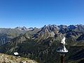
View from the summit of the Kanzelwand to Heilbronner Weg


literature
- 100 years of Heilbronner Weg. German Alpine Club Section Heilbronn, Heilbronn 1999
- Hans Kaiser: The Heilbronner Weg in the Allgäu Alps. In: 100 years of Heilbronn Section in the German Alpine Association. 1891-1991. Heilbronn section of the German Alpine Club, Heilbronn 1991, pp. 49–53
Web links
- Heilbronner Weg on via-ferrata.de (tour description + map)
- Heilbronner Weg at the DAV section Heilbronn
- Chronicle of the Heilbronner Weg at the DAV section Heilbronn