
Girl fork
| Girl fork | ||
|---|---|---|
 Girls fork from the south. Down the Black Spleen Remover (2009) |
||
| height |
2645 m above sea level NHN 2644 m above sea level A. |
|
| location | Border Bavaria , Germany / Tyrol , Austria | |
| Mountains | Central main ridge , Allgäu Alps | |
| Dominance | 0.4 km → Hochfrottspitze | |
| Notch height | 81 m ↓ notch to the Hochfrottspitze | |
| Coordinates | 47 ° 18 '0 " N , 10 ° 17' 45" E | |
|
||
| First ascent | 1818 | |
| Normal way | from Heilbronner Weg | |

The girl fork is a 2645 m above sea level. NHN high mountain in the Allgäu Alps . It is one of the most famous and most climbed high peaks in the German Alps. In the Allgäu Alps, it is the fourth highest peak with walls up to 400 meters high made of the main dolomite . Together with the Trettachspitze and the Hochfrottspitze , it forms the famous triumvirate on the Allgäu main ridge. The name comes from Mähder (a mown mountain meadow) nearby; Gabel stems from the appearance of the triumvirate to the north, which is reminiscent of a fork. Originally, Mädelegabel was the name for all three peaks of the triumvirate, but a distinction was made later.
The border between Bavaria and Austria runs over the ridge . On the south-east side is the Schwarzmilzferner , a small glacier.
The very popular Heilbronner Weg leads south below the summit .
Ascent
The girl fork can be reached quickly from Heilbronner Weg . To do this, turn off the Heilbronner Weg on the back just above the Schwarzmilzferner and follow the marked route with climbing to UIAA I + in 30 minutes , which is fairly unproblematic due to its low exposure and the solid rock. The mountain has accordingly many visitors. As a hut bases come Walt Berger house (walking to the summit 2.5 h), Kempten hut (2.75 h) and Rappenseehütte (5 h) in question. From the Lech Valley - possibly with an overnight stay at the Kemptner Hütte - the girls fork is a popular spring ski tour. The first ascent is likely to have been carried out during surveying work in 1818/19 and during work by the border commission in 1835. An ascent in 1852 by Otto Sendtner on today's normal route is guaranteed .
photos
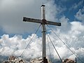
Summit cross

Mädelegabelgruppe from Guggersee from northwest

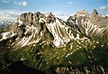
Hochfrottspitze (left), Mädelegabel (middle) and Trettachspitze (right) from the east.
View of the Mädelegabel (second summit from the right) - the Kratzer on the left and the Kemptner Hut on the left


literature
- Ernst Enzenperger: The girl fork group , Munich, Jos. Köselsche Buchhandlung, 1909
- Thaddäus Steiner : Allgäu mountain names . Kunstverlag Josef Fink, Lindenberg 2007, ISBN 978-3-89870-389-5 .
- Thaddäus Steiner: The field names of the municipality of Oberstdorf im Allgäu , Volume II, self-published by the Association for Field Name Research, Munich 1972
- Dieter Seibert: AVF Allgäu Alps . 16th edition. Bergverlag Rudolf Rother, Munich 2004, ISBN 3-7633-1126-2 .
- Alpine Club Map 1: 25,000, sheet 2/1, Allgäuer-Lechtal Alps, West
Web links
Individual evidence
- ↑ Bavarian Surveying Administration : BayernViewer 2.0 . Retrieved May 29, 2020.
- ^ Federal Office for Metrology and Surveying Austria: Austrian Map online (Austrian map 1: 50,000) .
- ↑ Ernst Zettler, Heinz Groth: Alpine Club Guide - Allgäu Alps . 12th, completely revised edition. Bergverlag Rudolf Rother, Munich 1985, ISBN 3-7633-1111-4 (p. 204).