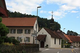
Hettenschwil
| Hettenschwil | ||
|---|---|---|
| State : |
|
|
| Canton : |
|
|
| District : | Zurzach | |
| Residential municipality : | Leuggern | |
| Postal code : | 5317 | |
| Coordinates : | 657.22 thousand / 269 864 | |
| Height : | 369 m above sea level M. | |
| Residents: | 222 (December 31, 2013) | |
|
Hettenschwil |
||
| map | ||
|
|
||
Hettenschwil is a village belonging to the Swiss municipality of Leuggern . It is located between Etzwil and Leuggern on the road that leads from Leuggern to Mandach .
The village lies in a hollow on the Guntenbach, which here changes its course from the south to the east and merges with the Belzbach, which flows in from the south-west. This stream has been partly overturned in order to gain cultivated land. 700 m below Hettenschwil, the Guntenbach squeezes through a narrow ravine before it is directed east of Leuggern through a canal into the Aare.
The village with its 222 inhabitants is characterized by agriculture. Hettenschwil has a kindergarten and there is an hourly bus connection via Leuggern to the train station in Döttingen .
Web links
Individual evidence
- ↑ Leuggern Online: Overview. (No longer available online.) In: leuggern.ch. Archived from the original on April 7, 2014 ; Retrieved April 3, 2014 . Info: The archive link was inserted automatically and has not yet been checked. Please check the original and archive link according to the instructions and then remove this notice.
www.hettenschwil.ch


