
Hilbre Islands
| Hilbre Islands | ||
|---|---|---|
 |
||
| Waters | Dee estuary | |
| Geographical location | 53 ° 23 ′ N , 3 ° 13 ′ W | |
|
||
| Number of islands | 3 | |
| Main island | Hilbre Island | |
| Total land area | 0.06 km² | |

The Hilbre Islands , partially uninhabited since 2012, are an archipelago of three tidal islands in the Dee estuary , which forms the border between England and Wales . The islands are administratively part of the Metropolitan Borough of Wirral and thus England.
The islands are a nature reserve and a "Site of Special Scientific Interest" ( German "Place of special scientific interest" ). During the summer months, tourists come to the islands from West Kirby on foot. The name is believed to come from a chapel on the island that is dedicated to St Hildeburgh.
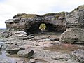
Hilbre Island, the largest island in the group, is approximately 4.7 acres and is located approximately 1.6 km from Red Rocks, the closest part of the mainland on the Wirral Peninsula . The other two islands are Middle Eye, which is about 1.2 hectares in size, and Little Eye, which is much smaller. All three islands are made of red sandstone . The main island and Middle Eye are less than a hundred meters apart. Hilbre Island is one of 43 tidal islands accessible on foot from mainland Great Britain at low tide. Little Eye and Middle Eye are uninhabited. There are a few private houses on Hilbre Island. The islands are believed to have been inhabited since the Stone Age. Finds from the Stone and Bronze Ages as well as Roman ceramics were discovered in 1926.
Hilbre Island may have been a hermitage or pilgrimage site before the Norman invasion. Around 1080 a Benedictine cell and church was founded on Hilbre Island. Although not named, it is believed that all three islands were mentioned in the Domesday Book, which mentions Chircheb (West Kirby) with two churches. One in the city and one on an island in the sea.
- The small islands

Lighthouse from 1995

Middle Eye
Middle Eye

Little Eye


The area was part of the land of the Norman Robert of Rhuddlan († 1093). He gave the islands to the Abbey of Saint-Evroul-sur-Ouche in Normandy , which in turn passed responsibility to the Abbey of St Werburgh in Chester . The islands became a popular place of pilgrimage in the 13th and 14th centuries. When the monasteries were dissolved, two monks were allowed to stay on the island as they maintained a beacon for navigation in the estuary. The last monk left the island around 1550 when a customs house was set up to collect taxes on the goods traded. John Leland describes Hilbre Island in his itineraries (around 1538–43). In 1692 a factory was founded to refine rock salt. There was also an eatery that opened when the writer Richard Ayton visited the island in 1813. With the siltation of the River Dee, trade shifted to the ports on the Mersey and trade disappeared from the island. Hilbre Island lighthouse was built in 1927.
literature
- Peter Caton: No Boat Required. Exploring Tidal Islands. Matador, London 2011, ISBN 978-1-84876-701-0 .