
Hochwaidkopf
| Hochwaidkopf | ||
|---|---|---|
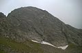
 Hochwaidkopf from the northeast |
||
| height | 2415 m above sea level A. | |
| location | Tyrol , Austria | |
| Mountains | Ötztal Alps | |
| Coordinates | 47 ° 2 '37 " N , 10 ° 49' 58" E | |
|
||
| First ascent | unknown | |

The Hochwaidkopf is an extremely eye-catching rock head near the Rofelewand in the Kaunergrat in the Ötztal Alps . It is higher and more rugged than the two neighboring peaks of the "first row", Rappenkopf and Rosskopf. It is the culmination point of a Gratzug that starts above the Arzler Alm and continues over it to the Rofelewand. Its extremely difficult and regular-looking record lines give it a distinctive look. On its plateau-like summit there is a stone man with a marker pole.
Routes
Of about this mountain is silent Alpine Club leaders from all over, but he is in the Alpenvereinskarte 3.30 (Kaunergrat) noted.
The ascent path leads from the Arzler Alm on the marked path towards Kreuzjoch up to the plateau below the Rofelewand. Continue up the path until you are slightly north of the ridge of the Hochwaidkopf. Now pathless up in steep terrain to the southwest along the foot of the rising ridge flank. Past some ridge ridges and the slabs of the Hochwaidkopf until steep, but accessible scree slopes enable the ascent to a ridge ridge southwest of the summit. With difficulty up to the notch and slightly to the left of the ridge edge over steep slabs to the summit plateau with Steinmann .
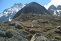
The plateaus of the Hochwaidkopf
Hochwaidkopf vom Rappenkopf (from the east)
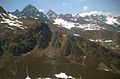
Hochwaidkopf and Rofelewand


literature
- Alpine club map sheet 30/3, 1: 25,000, Ötztal Alps, Kaunergrat . ISBN 978-3-928777-41-4