
Rofelewand
| Rofelewand | ||
|---|---|---|
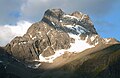
 Rofelewand vom Rappenkopf |
||
| height | 3353 m above sea level A. | |
| location | Tyrol , Austria | |
| Mountains | Ötztal Alps | |
| Dominance | 3.3 km → Verpeilspitze | |
| Notch height | 528 m ↓ Verpeiljoch | |
| Coordinates | 47 ° 1 ′ 0 ″ N , 10 ° 49 ′ 0 ″ E | |
|
||
| First ascent | July 24, 1873 by Theodor Petersen , Isidor Müller, Kaspar Neuner and Alois Neururer, led by Alois Ennemoser, Josef Kirschner and Gottlieb Rauch | |
| Normal way | through the ice channel ( II ) | |

The Rofelewand is 3353 m above sea level. A. high, double-peaked mountain in the Ötztal Alps and is considered one of the most beautiful mountains of the Kaunergrat between Pitztal and Kaunertal . It is one of the most challenging and rewarding alpine destinations in the region. Accordingly, the Rofelewand is sometimes referred to as the Matterhorn of the Kaunergrat .
Ascent history
The first ascent of the main summit was achieved by a group with Theodor Petersen , Isidor Müller, Kaspar Neuner and Alois Neururer with the guides Alois Ennemoser , Joseph Kirschner and Gottlieb Rauch on July 24, 1873. Theodor Petersen and guide Alois Ennemoser left at 2:50 am accompanied From the postmaster Kaspar Neuner, the photographer Isidor Müller from Landeck, the landlord Alois Neururer, as well as the gem hunter Gottlieb Rauch and Josef Kirschner the place St. Leonhard im Pitztal . You climbed through the forest to the Arzler Alm in about an hour. From there they stayed south, leaving the steep walls of the Rofelewand and a pre-summit on the right, a protruding ridge, the cat's head, on the left, and in an hour reached the moraine of the Totenkarferner over scree . One stepped on the rocks on the left side of the glacier and climbed up to the foot of a steep snow field. The increasing slope required long steps. At a high altitude, you turned more north, to a snow-covered ice channel. After overcoming this 50 ° steep couloir , the highest ridge was reached and after a 5 hour and 10 minute ascent from St. Leonhard you reached the summit of the mountain via a sharp snow edge. The lower east summit, which Gottlieb Rauch had conquered a year earlier, was also climbed. The descent to St. Leonhard took 2 hours 55 minutes.
Routes

The Rofelewand has various climbing routes, some of which are very difficult, which is already obvious when you look at the mountain. The most frequently used route leads over the upper glacier basins of the Schweickert and Totenkarferner and over a very steep and often dangerous “ice channel” (45 °, approx. 150 meters in altitude) up to the summit ridge. The difficulties in the ice channel depend very much on the conditions. The ice channel has already claimed several victims, including extreme mountaineer Günter Hafele, who died there on June 19, 2000. In the late summer, the channel is now completely free of ice.
Most of the time, the tour is started from the Kaunertal and the Verpeilhütte (2025 m) is used as a base. The Arzler Alm (1875 m) is located on the route from the Pitztal, although there is no overnight accommodation. If the mountain is climbed directly from the Pitztal , about 2000 meters in altitude have to be overcome to the summit.
The most famous routes are the following:
- Eisrinne (II) from the Verpeilhütte: 4–5 hours, approx. 1300 m ascent
The route leads from the Verpeilhütte to a lake below the Schweickertferner and further on the Schweickertferner to the lower part of the Eisrinne. You can reach the summit ridge via the ice gully. - Eisrinne (II) from Piösmes in the Pitztal: 6–7 hours, approx. 2000 m
ascent From Piösmes you can reach the Arzler Alm via a steep path. The path continues across the plateau near the mountain to the Totenkarferner. Over this it goes up to the uppermost glacier basin next to the channel, which is reached over a rock ridge. - East ridge (IV), 8-10 hours from the start
From the above-mentioned plateau near the Arzler Alm, you climb over gullies to a ridge gap beyond the Katzenkopf. There is a difficult climb waiting on an exposed ridge. The ridge itself has two large upswings and is quite exposed. - Südrippe (III)
Similar route as the normal route but avoiding the often dangerous ice gully by climbing directly to the right of the gully over the rocks to the summit ridge.
The route of the first to climb over the south shoulder is no longer possible due to the retreat of the glacier.
Impressions
Rofelewand in the morning light

East ridge
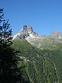
Rofelewand from the east


Literature and map
- Walter Klier: Alpine Club Guide Ötztal Alps. Bergverlag Rudolf Rother, Munich 2006, ISBN 3-7633-1123-8 .
- Richard Goedeke : 3000 meters in the northern Alps. Bruckmann, Munich 2004, ISBN 3-7654-3930-4 .
- Alpine club map sheet 30/3, 1: 25,000, Ötztal Alps, Kaunergrat. 2014, ISBN 978-3-928777-41-4 .
Web links
Individual evidence
- ↑ Clem Clements, Jonathan de Ferranti, Eberhard Jurgalski , Mark Trengove: The 3000 m SUMMITS of AUSTRIA - 242 peaks with at least 150 m of prominence , October 2011, p. 8.
- ↑ Federal Office for Metrology and Surveying Austria: Rofelewand on the Austrian Map online (Austrian map 1: 50,000) .
- ↑ Eduard Richter: The development of the Eastern Alps. Volume II, Berlin 1894, p. 313.
- ^ Journal of the German and Austrian Alpine Club , Volume 35, 1904, p. 311