
Verpeilspitze
| Verpeilspitze | ||
|---|---|---|
 Verpeilspitze from the Parstleswand |
||
| height | 3423 m above sea level A. | |
| location | Tyrol , Austria | |
| Mountains | Ötztal Alps | |
| Dominance | 1.6 km → Watzespitze | |
| Notch height | 403 m ↓ Snowy Madatschjoch | |
| Coordinates | 47 ° 0 '12 " N , 10 ° 48' 18" E | |
|
||
| First ascent | September 4, 1886 by Theodor Petersen and Anna Voigt, led by Stefan Kirschner, Johann Penz and Johann Praxmarer | |
| Normal way | From the southwest and over the southeast ridge ( II ) | |

The Verpeilspitze is 3423 m above sea level. A. high, rugged mountain in the Kaunergrat between Kaunertal and Pitztal and is located north of the Kaunergrathütte and south of the Verpeiljoch (also Neururer Joch). Long ridges run from the summit to the west and north. The southeast ridge, via which the easiest climb is made, turns after less than a kilometer to the east to the Parstleswand . To the northwest, southwest and east, the summit shows steep walls and flanks. On the eastern flank is the Neururer Ferner , which today has split into two parts .
Normal way

The easiest ascent leads from the Kaunergrathütte first to the west, together with the path to the Madatschjoch . The path branches off to the right at a signpost, heading north, initially together with the ascent to the Schwabenjoch. In the wide southwest flank of the Verpeilspitze, the ascent now leads through a steep rubble channel - in early summer more of a snow channel - quite straight into a notch of the southeast ridge. The entrance to this channel is marked with a red dot. Now on the partly wide, partly covered south-east ridge to below the summit wall. Left (west) first through a short chimney to a notch. Further on the west side on ribbons crossing several gullies southeast again to the ridge and on this to the summit. There are security options on the southeast ridge, which are also a guide. The ascent is ice-free in summer and shows climbing difficulties of the II . Difficulty level. From the Kaunergrathütte it takes 3 hours.
Ascent history
The first ascent was made on September 4, 1886 by Theodor Petersen and Anna Voigt from Erfurt , accompanied by guides Stefan Kirschler, Johann Penz and Johann Praxmarer. The ascent took place via the south-west side and the south-east ridge, presumably on the normal route that is customary today; this cannot be reconstructed beyond doubt with Petersen's inaccurate and sometimes contradicting records. The starting point of the ascent was the Verpeiltal, from there the first climbers reached the south-west side of the mountain via the Rotenkarferner, which no longer exists today, and the Plangerossferner , which can no longer be found at this point today .
The second ascent is not documented until eleven years later; Ferdinand Hennig, Emil and Karl Sommer carried it out on August 11, 1897. Their ascent led directly through the south-west flank of the mountain, on the descent they came back to the Plangeroßferner via the path of the first ascent, the south-east ridge . Jakob Albert and Ingenuin Hechenblaikner made the first ascent over the east face on August 19, 1902.
Route pictures

The gutter entrance

At the end of the channel (steep section)

In the Schuttkar under the SE ridge

On the SE ridge towards the summit wall
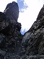
In the chimney to the rock spur


literature
- Walter Klier : Alpine Club Guide Ötztaler Alpen , Bergverlag Rudolf Rother , Munich 2006. ISBN 3-7633-1123-8
- Alpine club map sheet 30/3, 1: 25,000, Ötztal Alps, Kaunergrat . ISBN 978-3-928777-41-4
Individual evidence
- ↑ Clem Clements, Jonathan de Ferranti, Eberhard Jurgalski , Mark Trengove: The 3000 m SUMMITS of AUSTRIA - 242 peaks with at least 150 m of prominence , October 2011, p. 8.
- ↑ Federal Office for Metrology and Surveying Austria: Verpeilspitze on the Austrian Map online (Austrian map 1: 50,000) .
- ^ A b Franz Hörtnagl : The Kaunergrat in the Ötztal Alps . In: Journal of the German and Austrian Alpine Club . Volume 35, born in 1904, published by the German and Austrian Alpine Club, Innsbruck