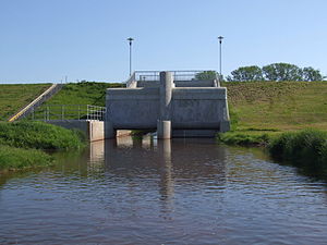
Erftstadt-Niederberg flood retention basin
| Erftstadt-Niederberg flood retention basin | |||||||
|---|---|---|---|---|---|---|---|
| Rotbach flood retention basin near Erftstadt-Niederberg | |||||||
|
|||||||
|
|
|||||||
| Coordinates | 50 ° 44 '0 " N , 6 ° 45' 38" E | ||||||
| Data on the structure | |||||||
| Construction time: | 2004 - 2006 | ||||||
| Height above foundation level : | 6.50 m | ||||||
| Building volume: | 0.12 million m³ | ||||||
| Crown length: | 669 m | ||||||
| Slope slope on the air side : | 1: 3 - 1: 5 | ||||||
| Slope slope on the water side : | 1: 3 - 1: 5 | ||||||
| Data on the reservoir | |||||||
| Water surface | 60 ha | ||||||
| Storage space | 1 million m³ | ||||||
| Catchment area | 175 km² | ||||||
The Erftstadt-Niederberg flood retention basin is a flood retention basin of the Erftverband on Rotbach , a tributary of the Erft in North Rhine-Westphalia . It protects Erftstadt and especially the Friesheim district adjoining Niederberg from flooding . The basin was completed in 2006 for 7.8 million euros and can hold one million cubic meters of water.
For this purpose, a 669 m long and up to 6.5 m high dam was built from earth material.


