
Eringerfeld flood retention basin
| Eringerfeld flood retention basin | |||||||||
|---|---|---|---|---|---|---|---|---|---|
 |
|||||||||
|
|||||||||
|
|||||||||
| Coordinates | 51 ° 35 ′ 55 " N , 8 ° 28 ′ 17" E | ||||||||
| Data on the structure | |||||||||
| Lock type: | Earthfill dam | ||||||||
| Construction time: | 1977-1988 | ||||||||
| Height above valley floor: | 17 m | ||||||||
| Height of the structure crown: | 169 m above sea level NN | ||||||||
| Building volume: | 144,000 m³ | ||||||||
| Crown length: | 247 m | ||||||||
| Crown width: | 5 m | ||||||||
| Slope slope on the air side : | 1: 2.1; 1: 2.3 and 1: 2.5 | ||||||||
| Slope slope on the water side : | 1: 1.9 and 1: 2.5 | ||||||||
| Operator: | Upper Lippe Water Association (WOL) | ||||||||
| Data on the reservoir | |||||||||
| Altitude (at congestion destination ) | 166.5 m above sea level NN | ||||||||
| Water surface | 17.9 ha | ||||||||
| Storage space | 1.06 million m³ | ||||||||
| Total storage space : | 1.24 million m³ | ||||||||
| Catchment area | 25 km² | ||||||||
| Design flood : | 70 m³ / s | ||||||||

The Eringerfeld flood retention basin is a flood retention basin of the Obere Lippe water association in the Soest district in North Rhine-Westphalia . It lies between Steinhausen and Eringerfeld.
The construction material of the dam is rock fill material as a support body with an interior seal made of clay on the water side.
The basin has a bottom outlet with an output of 15.5 m³ / s.
The sources give inconsistent information about the size of the reservoir and other dimensions.
Picture gallery

Inlet structure flood relief

Operations building and bottom outlet
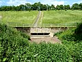
Inlet structure bottom outlet


See also
Individual evidence
- ↑ a b c d e f g h i j k l m n Wasserverband Obere Lippe: HRB Eringerfeld (accessed on June 17, 2012)
Web links
- Summary of the main data - HRB Eringerfeld
- Dams directory NRW (PDF; 122 kB)
- Dams in North Rhine-Westphalia; State Environment Agency NRW (PDF; 124 kB)