
Lauenstein flood retention basin
| Lauenstein flood retention basin | |||||||
|---|---|---|---|---|---|---|---|
 |
|||||||
|
|||||||
|
|||||||
| Coordinates | 50 ° 46 '43 " N , 13 ° 50' 12" E | ||||||
| Data on the structure | |||||||
| Construction time: | 2001-2006 | ||||||
| Height above valley floor: | 41.4 m | ||||||
| Height of the structure crown: | 554.2 m | ||||||
| Building volume: | 480 000 m³ | ||||||
| Crown length: | 260 m | ||||||
| Crown width: | 5 m | ||||||
| Data on the reservoir | |||||||
| Altitude (at congestion destination ) | 551.3 m | ||||||
| Water surface | 38 ha | ||||||
| Storage space | 5.19 million m³ | ||||||
| Catchment area | 38.1 km² | ||||||

The flood retention basin Lauenstein (old name flood retention basin Müglitztal ) is a retention basin in the Free State of Saxony on the upper reaches of the Müglitz . It is used for flood protection in the Müglitztal and cost 38.7 million euros.
location
The retention basin is located in the Eastern Ore Mountains . The town of Lauenstein is located below the outlet . The connecting roads from Löwenhain and Fürstenwalde to Lauenstein and Liebenau in the direction of the Breitenau motorway junction to the A 17 are located in the reservoir's storage space .
Barrier structure
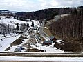
The barrier structure is a dam made of stone fill with an asphalt concrete inner seal. The structure was built from 2002 to 2006 near Lauenstein (foundation stone laid on August 5, 2002, inauguration on August 25, 2006). The dammed water is the Müglitz. In continuous operation, a small part of the pool is filled with 0.2 million m³ of water. It then has an area of 4.5 hectares. Initially, a reservoir with half the volume was planned. After the flood of the century in 2002 , planning was changed. The dam was now 8.5 m higher and the storage capacity doubled to 5.19 million cubic meters. The catchment area is 38.1 km². The rock embankment dam consists of 1 million tons of rock material, is 41.4 m high and 260 m wide. The total storage area is 38 ha.
Construction work
In 2004, the construction work on the diversion tunnel and the road works were completed and the embankment began to be filled.

Construction of the dam (January 13, 2005)

Construction of the retention basin (November 5, 2005)

partially flooded retention basin (March 29, 2006)
View from the top of the dam into the Müglitztal (April 2, 2006)


Planning history
As early as July 10, 1901, the Royal Saxon Ministry of Finance passed the resolution “No. 263 Wasserbau - Reg. ”For submission to the Ministry of the Interior as to whether it is technically possible to build dams in the Müglitztal.
In 1936/37 further plans were made for a dam made of quarry stone masonry near Lauenstein. This dam should reach a height of 23 meters. The two relief pipes should be in the middle of the structure at ground level (509 m).
In the 1970s, another attempt was made to build a dam. This was mainly intended for the drinking water supply of Dresden. A quarry near Fürstenwalde was opened and large areas of forest were cut down. In Löwenhain the houses up to the Fürstenau junction were to be torn away, in Fürstenwalde the houses up to the bakery.
After the river floods in 1997 , the Saxon government decided to build a flood retention basin. It was not until 2002 that construction actually began. The construction work was stopped after the August floods in 2002 because it was recognized that the storage space would have been too small. It was now decided to build a pool that was twice as large as it was actually built afterwards.
Flood in the Müglitztal

- Flood 1559
- Waterspout 1890
- Flood 1897
- Flood 1926
- Floods in the Eastern Ore Mountains in 1927
- Flood 1934
- Flood in 1948
- 1957 flood
- 1958 flood
- Elbe floods in 2002
Freetime activities
Presumably, there will be no recreational opportunities at the reservoir, as no investor has been found, but in the summer of 2006 some bathers had already settled.