Horbach (Ruhr)
| Horbach | ||
|
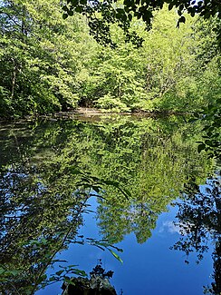
Upper pond in the Horbach valley |
||
| Data | ||
| Water code | DE : 2769992 | |
| location | North Rhine-Westphalia , Germany | |
| River system | Dysentery | |
| Drain over | Ruhr → Rhine → North Sea | |
| source | LSG Horbachtal, Dümpten 51 ° 27 ′ 4 ″ N , 6 ° 54 ′ 2 ″ E |
|
| muzzle | In Mülheim in the Ruhr Coordinates: 51 ° 26 '13 " N , 6 ° 52' 6" E 51 ° 26 '13 " N , 6 ° 52' 6" E
|
|
| length | 2.9 km | |
| Big cities | Mülheim an der Ruhr | |
The Horbach is 2.9 km long, right tributary of the Ruhr between Eppinghofen and Styrum in Mülheim an der Ruhr (DGKZ 276 9992). Its source is in the Horbach Valley at the Erich Kästner Comprehensive School on Nordstrasse. It flows off in a south-westerly direction. He crosses two fish ponds. Even before it crosses under Mellinghofer Straße, it is already closed with pipes. It flows into the Ruhr 12.425 km before its mouth with the Rhine.
Web links
Commons : Horbach (Ruhr) - Collection of images
Individual evidence
- ↑ a b Topographical Information Management, Cologne District Government, Department GEObasis NRW ( information ) with an additional water station map
- ↑ Template - V 19 / 0016-01. In: Mülheim an der Ruhr meeting service. Retrieved April 26, 2020 .
