
Hornos (Chile)
| Isla Hornos | ||
|---|---|---|
 |
||
| Waters | Drake Street | |
| Archipelago | Hermite Islands ( Tierra del Fuego ) | |
| Geographical location | 55 ° 56 ′ 50 ″ S , 67 ° 16 ′ 15 ″ W | |
|
||
| length | 9.7 km | |
| width | 5.4 km | |
| surface | 28.29 km² | |
| Highest elevation | 425 m | |
| Residents | 4th <1 inh / km² |
|
| main place | (Estación Meteorológica de Cabo de Hornos) | |
 |
||

Hornos ( Spanish Isla Hornos ) is an approximately 6 km long and 2 km wide island in the Chilean part of Tierra del Fuego , at the southern tip of which is the famous Cape Horn . The island belongs to the Hermite Islands and is located directly to the north of the Drake Strait between the Tierra del Fuego archipelago and the Antarctic Graham Land .
Hornos is sometimes referred to as the southernmost point of America - and thus of the inhabited continents . In fact, it is only the southernmost island immediately in front of South America. The southernmost American islands are the Diego Ramírez Islands , which are located about 100 km further south-west and also belong to Chile .
There is a lighthouse on Hornos, the crew of which is changed every three months. There is also a small chapel and a post office hut as well as a meteorological station ( Estación Meteorológica de Cabo de Hornos ).
The Yámana ( Yaghanen ), a nomadic Indian tribe who populated the islands of this area , lived on Hornos and the neighboring islands until the end of the 18th century . With them ended at Cape Horn the millennia-long migration of Indian peoples, who descended from the Mongolian peoples of East Asia , crossed the Bering Strait and crossed the entire American continent from Alaska, only to find their home after a journey of more than 20,000 km on the extreme southern tip of South America.
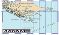
Tierra del Fuego with Cape Horn ("Cape Horn") on Hornos
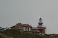
Lighthouse on Hornos
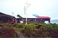
Weather station at Cape Horn

Kaphoorniers monument: Albatros on Hornos

Hornos satellite image
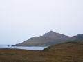
Cape Horn seen from another part of the island


