Hortolândia
| Hortolândia | |
|---|---|
|
Coordinates: 22 ° 51 ′ S , 47 ° 13 ′ W
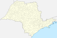
Hortolândia on the map of São Paulo
|
|
| Basic data | |
| Country | Brazil |
| State | São Paulo |
| City foundation | May 19, 1991 |
| Residents | 192,692 (IBGE / 2010) |
| - in the metropolitan area | about 1.5 million |
| City insignia | |
| Detailed data | |
| surface | 62 km² |
| height | 587 m |
| Time zone | UTC −3 |
| City Presidency | Ângelo Augusto Perugini |
| Website | |
| Location of the municipality of Hortolândia in the state of São Paulo | |
Hortolândia is a municipality in the interior of the Brazilian state of São Paulo . According to official estimates, around 227,400 people lived in Hortolândia in 2018.
location
The city is located at 47 ° 13 'West and 22 ° 51' South, in the RMC (Região Metropolitana de Campinas) at a distance of 40 kilometers from Campinas and 62 kilometers from the city of São Paulo . The municipal area covers an area of 134 km².
history
The municipality of Hortolândia was founded in 1991 following a referendum. It was created by splitting off parts of the Sumaré community .
climate
In a tropical climate, the city has an average temperature of 21 ° C. The hottest month is February with an average temperature of 24 ° C, with the average maximum being 30 ° C.
economy
The community is home to numerous high-tech companies, such as a subsidiary of IBM . Universities, including the denominational Centro Universitário Adventista de São Paulo (UNASP) with the Instituto Adventista de São Paulo (IASP), also operate a campus in the community.
Web links
- City Prefecture website , Prefeitura Municipal (Portuguese)
- City Council website , Câmara Municipal (Portuguese)
Individual evidence
- ↑ IBGE to Hortolândia. Retrieved June 2, 2019 .
- ^ Website of the IASP . Retrieved March 28, 2018 (Portuguese).


