
Hunga Tonga
.jpg)
Hunga Tonga-Hunga Haʻapai is a volcano on the island of Hunga Tonga , part of the Pacific island nation of Tonga . The volcanic island is located in the Haʻapai group of islands about 24 kilometers south-southeast of Fonuafoʻou (also known as Falcon Island). At its highest point it is 149 m high.
volcanology
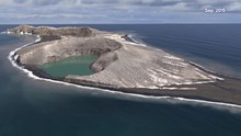
In late December 2014, the volcano erupted for the second time in five years, creating a new patch of land between two islands it had previously carved. The island is mainly formed by the accumulation of fragmented igneous rocks. It is perched on the northern rim of the caldera of the underwater volcano, which rises almost 1400 meters above the surrounding sea floor.
The formation of the island could be observed with modern satellite technology. Newly formed volcanic islands are often destroyed again by erosion ; the islanding of 2014 stabilized after about six months.
In October 2018, NASA scientists visited Hunga Tonga and were able to observe plant roots forming everywhere, as well as the construction of swallow nests and also an owl . The island was also covered by a sticky, light-colored mud reminiscent of clay , but its origin was unclear at the time.
On December 20, 2021, Tonga-Hunga erupted again: smoke was measured at a height of up to 15 kilometers. The dark ash cloud was mainly limited to an altitude of 5000 meters and below. The eruption was a phreatomagmatic explosion caused by the contact of magma with seawater . The eruptions continued over the Christmas holidays; even at the turn of the year the volcano did not tire. The outbreak temporarily ended on January 2, 2022. The island grew more than 2.5 square kilometers during the eruptions.
Eruption in mid-January 2022

After several days of quiescence, more massive eruptions occurred on January 14 and 15, 2022, which, like those in December, were phreatomagmatic in nature. On January 15 at 04:14:14 UTC (17:14:14 local time) an earthquake magnitude of 5.8 on the surface acoustic wave magnitude scale was recorded. The Volcanic Ash Advisory Center in Wellington , New Zealand , reported ash at a height of 18.6 km, setting a record for 2021/2022. Estimates even assume a height of up to 30 km (upper, warm stratosphere ).
The pressure waves from the eruption moved around the globe; they met in Algeria , diametrically opposed to Tonga, late in the evening. In Germany they were measured at 9:00 p.m. Central European Time with an air pressure pulse of approx. 1.5 hPa, on the following day at approx. 2:00 a.m. from the other direction with a somewhat weaker barometer amplitude .
A tsunami was triggered by the eruptions . B. Nukuʻalofa (The capital of Tonga) with a height of 1.20 meters. For the US territory of American Samoa , there was a risk of tidal waves and dangerous ocean currents along the beaches and ports. Low-lying coastal areas could be flooded, the Pacific Tsunami Warning Center said in a warning that was later lifted. New Zealand's National Disaster Management Agency warned that "strong and unusual currents and unpredictable surges " could be expected in some parts of the country . In fact, several boats capsized in a harbor there. Flooding also occurred in California . The estimated population within a 100 km radius of the volcano is 76,000. Tonga was largely covered by 1 to 2 cm of volcanic ash from the volcanic eruption, which is currently affecting water, electricity and air quality.
Radar images from January 15 show that large parts of the island were destroyed in the eruption.
web links
- Hunga Tonga-Hunga Haʻapai in the Smithsonian Institution 's Global Volcanism Program
- NASA Shows New Tongan Island Made of Tuff Stuff, Likely to Persist Years , NASA, December 11, 2017
- Making a Connection in the Kingdom of Tonga , NASA Earth Observatory, November 20, 2019
- Hunga Tonga-Hunga Ha'apai Erupts Again , NOAA : National Environmental Satellite Data and Information Service, January 14, 2022 (English)
- Satellite images show eruption of underwater volcano Spiegel Wissenschaft, January 15, 2022 (German)
- Sound wave of the eruption in the difference plot of the IR satellite image
itemizations
- ↑ NASA Shows New Tongan Island Made of Tuff Stuff, Likely to Persist Years , NASA, December 11, 2017 (English), accessed January 16, 2022. - With 2 videos on Youtube: NASA Goddard: The Birth of a New Island ( 2017) (5:28). NASA Goddard: A New Time-lapse Forming an Island in Tonga (2017) (0:57).
- ↑ Christoph Seidler: Tonga: New island surprisingly stable, helps Mars researchers . In: The Mirror . December 13, 2017, ISSN 2195-1349 ( spiegel.de [accessed January 16, 2022]).
- ↑ Country Ho! Visiting a Young Island. January 30, 2019, retrieved February 6, 2019 (English).
- ↑ M 5.8 Volcanic Eruption - 68 km NNW of Nuku'alofa, Tonga , USGS Earthquakes Hazards Program, accessed January 15, 2022.
- ↑ Karsten Schwanke / twitter January 16, around 7:15 p.m., via Philippe Papin, pppapin.com , also Twitter
- ↑ Viola Kiel: Tonga: How an Undersea Volcano Can Develop Destructive Power . In: The Mirror . January 16, 2022, ISSN 2195-1349 ( spiegel.de [accessed January 16, 2022]).
- ↑ Twitter posts, e.g. B by Karsten Schwanke etc.
- ↑ Tonga: South Pacific tsunami warning after underwater volcano erupts . In: The Mirror . January 15, 2022, ISSN 2195-1349 ( spiegel.de [accessed January 16, 2022]).
- ↑ tagesschau.de: Volcanic eruption: Extent of damage to Tonga still unclear. Retrieved January 16, 2022 .
- ↑ tagesschau.de: Tsunami warning after volcanic eruption - consequences still unclear. Retrieved January 15, 2022 .
- ↑ www.civildefence.govt.nz , daily update, accessed 16 January 2022. Report is expected to be moved later to Previous Emergencies, www.civildefence.govt.nz
- ↑ Peter Vincent, Tsunami warning issued for Australia and New Zealand after huge undersea volcano eruption visible from space sends 4ft waves smashing into Tonga and forces hundreds to flee to high ground In: Daily Mail , 15 January 2022, accessed 15 January 2022 .
- ↑ South Pacific tsunami warning , Der Spiegel, January 15, 2022.
- ↑ Tonga hit by tsunami after volcanic eruption , Deutsche Welle, January 15, 2022.
- ↑ tagesschau.de: Volcanic eruption: Extent of damage to Tonga still unclear. Retrieved January 16, 2022 .
- ↑ UNICEF Pacific Islands Humanitarian Situation Report No. 1 (Volcanic Eruption and Tsunami): 16 January 2022 In: reliefweb.int , 16 January 2022, accessed 16 January 2022
- ↑ Pacific volcano: New Zealand sends flight to assess Tonga damage. BBC News , 16 January 2022 (accessed 17 January 2022).
Coordinates: 20° 33′ S , 175° 24′ W