Hungelbrunn
| Hungelbrunn | |
|---|---|
| coat of arms | map |

|

|
Hungelbrunn was until 1850 an independent municipality and is now a district of Vienna in the 4th district of Vienna , Wieden and Vienna since 1861 also in the 5th district, Margareten . The map on the right shows both parts of Hungelbrunn that are not connected.
Hungelbrunn is located south of the Wiedner Hauptstrasse . The smaller, eastern part belongs to Wieden. It can be found between Schönburgstrasse , Rainergasse and Trappelgasse .
The area was first mentioned in a document around 1363 as the Hungerprunn . The place itself did not emerge until around 1609, until then mainly vineyards were found in the area . The name is derived from a legendary fountain , the Hungelbrunnen. The place grew only slowly, in 1846 there were only eleven houses. In 1850 the place became a part of Vienna in the new 4th district, Wieden. Hungelbrunn was the smallest incorporated suburb of Vienna.
With the reorganization of this 4th district into the new districts 4 and 5, the larger, western part of Hungelbrunn became part of the new 5th district, Margareten, in 1861. In the following years the area was heavily built up.
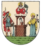
Hungelbrunn's coat of arms shows a fountain flanked by Saints Peter and Florian . Saint Leopold is above the fountain .
The infirmary for the Klagbaum was located in Hungelbrunn until 1785 .
Individual evidence
- ↑ wien.at - District coat of arms of the 4th district of Wieden ( Memento of the original from September 18, 2011 in the Internet Archive ) Info: The archive link was inserted automatically and has not yet been checked. Please check the original and archive link according to the instructions and then remove this notice.
Coordinates: 48 ° 11 ' N , 16 ° 22' E
