Hvítárvatn
| Hvítárvatn | ||
|---|---|---|

|
||
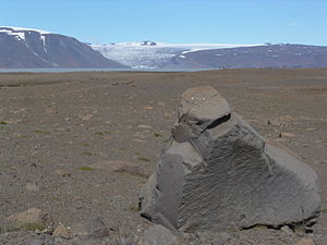
| Hvítárvatn from the direction of Kjölur | ||
| Geographical location | Iceland | |
| Tributaries | Fúlakvisl | |
| Drain | Hvítá | |
| Data | ||
| Coordinates | 64 ° 36 ′ 30 ″ N , 19 ° 50 ′ 0 ″ W | |
|
|
||
| Altitude above sea level | 419 m | |
| surface | 29.6 km² | |
| Maximum depth | 84 m | |
The lake Hvítárvatn located in the Icelandic highlands . It is also called Hvítárlón . The lake is located in the municipality of Bláskógabyggð .
Location and dates
It is located near the southern part of the Kjölur highland slope and east of the Langjökull glacier at an altitude of 419 m. Its surface is about 29.6 km², its greatest depth 84 m.
Surname
The name refers to the Hvítá river , which rises from the lake. It literally means Weißachsee , which indicates glacier water . The light color of the lake actually comes from its tributary Fúlakvisl , a river that rises from Langjökull.
Langjökull valley glacier
In addition, some valley glaciers of this large glacier extend to the lake, so that you can sometimes see smaller icebergs swimming there.
Overland slopes
In earlier times, the old Kjalvegur ran right along the lake, but was cut off by one of the glacier tongues that pushed forward as the climate cooled.
See also
Web links
Photos and videos
Scientific contributions
- Gwen E. Flowers, ea: Holocene climate conditions and glacier variation in central Iceland from physical modeling and empirical evidence. Quaternary Science Reviews , Vol. 27, iss. 7-8, 797-813; doi : 10.1016 / j.quasivrev.2007.12.004 (German: Holocene developments on Hvítárvatn and Langjökull)
- Darren J. Larsen, ea: A 3000-year varved record of glacier activity and climate change from the proglacial lake Hvítárvatn, Iceland. Quaternary Science Reviews , Vol. 30, iss. 19-20, 2715-2731; doi : 10.1016 / j.quasivrev.2011.05.026
