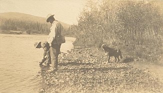
Indian River (Yukon River)
| Indian River | ||
|
Gold prospector on the Indian River in 1904 |
||
| Data | ||
| location | Yukon ( Canada ) | |
| River system | Yukon River | |
| Drain over | Yukon River → Bering Sea | |
| Confluence of | Wounded Moose Creek, Dominion Creek, and Scribner Creek 63 ° 37 ′ 9 ″ N , 138 ° 42 ′ 14 ″ W |
|
| Source height | 487 m | |
| muzzle |
Yukon River Coordinates: 63 ° 47 '3 " N , 139 ° 43' 47" W 63 ° 47 '3 " N , 139 ° 43' 47" W. |
|
| Mouth height | 333 m | |
| Height difference | 154 m | |
| Bottom slope | approx. 1.9 ‰ | |
| length | approx. 80 km | |
| Catchment area | 2220 km² (12 km above the mouth) | |
| Discharge at level 5829 A Eo : 2220 km² Location: 12 km above the mouth |
MQ 1982/2000 Mq 1982/2000 |
5.86 m³ / s 2.6 l / (s km²) |
The Indian River (English for "Indian River") is a right tributary of the Yukon River in the Canadian Yukon Territory .
The Indian River arises at the confluence of Wounded Moose Creek , Dominion Creek and Scribner Creek , 5 km southwest of the Dominion settlement . The Indian River flows through the Klondike Plateau in a predominantly west-northwest direction and flows into the Yukon River after a distance of about 80 km 35 km south-southwest of Dawson . Particularly in the middle section, the river shows a strongly meandering behavior with many narrow river loops. The catchment area of the Indian River covers about 2220 km².
There are numerous gold mines in the valley of the Indian River and in the valleys of the tributaries . There are numerous pits and quarry ponds along the rivers. Besides gold, other minerals are extracted from the river sediments.
