Irish Grid
The Irish Grid is the coordinate system used on the maps of Ireland . It is used consistently in both the Republic of Ireland and Northern Ireland , but differs from the National Grid of the British Ordnance Survey .
The reference ellipsoid for the national survey is the modified Airy ellipsoid. A transverse Mercator projection is used as a map projection , the (true) origin of which is 53 ° 30 ′ N and 8 ° W. A Cartesian coordinate system is defined in this origin . In order to avoid negative coordinates, 200 km are added to all values in east direction (“eastward value”) and 250 km to all values in north direction (“high value”). Coordinates are usually given in meters, so that z. B. the origin mentioned receives the coordinates 200,000 250,000 . (The point with the coordinates 0 0 is also known as the "wrong origin" of the map projection. It is located southwest of the island.)
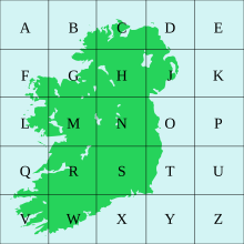
In order to arrive at more manageable coordinates, the map is divided into grid squares with a side length of 100 km, which are identified with the letters A to Z (without the capital I). Some squares are outside Ireland and are not used.
Within these 100 km squares, the kilometers are numbered from 00 to 99. A letter and two five-digit numbers are then required for coordinates that are accurate to the meter.
Example: The Half Penny Bridge is in WGS84 at 53 ° 20 ′ 46.7 ″ N 6 ° 15 ′ 47.1 ″ W. In the Irish grid this is 315725 234278 or O 15725 34278 .
Instead of such precise coordinates, generally only a grid square is given, i.e. O 15 34 (accurate to 1 km) or O 157 342 (accurate to 100 m).
See also
Web links
- The Irish Grid (PDF; 577 kB)
- Irish Grid & Grid Square References
- Co-ordinate converter. Ordnance Survey Ireland, accessed September 13, 2017 .
