Isla Danzante
| Isla Danzante | ||
|---|---|---|
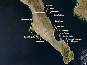
| Satellite map showing the islands in the southern Gulf of California | ||
| Waters | Gulf of California | |
| Geographical location | 25 ° 47 '11 " N , 111 ° 15' 8" W | |
|
|
||
| length | 5.5 km | |
| width | 1.6 km | |
| surface | 4.154 km² | |
| Residents | uninhabited | |
Isla Danzante ( German "Dancing Island" ) is a Mexican island in the south of the Gulf of California . Administratively it belongs to the municipality ( municipio ) Loreto in the state of Baja California Sur ("Southern Baja California ").
geography
Isla Danzante is located in the south of the Bahía de Loreto halfway between the Baja California peninsula and the island of Carmen , from which it is about 2 km away. Loreto , the main town in the municipality, is a good 25 km to the north-west. The mountainous and uninhabited island is about 5.5 km long in north-south direction, up to 1.6 km wide in east-west direction and has an area of 4.15 km². In the north of the island there is an approximately 200 m long peninsula that is only connected to the main island by a narrow isthmus . Isla Danzante is part of the Bahía de Loreto National Park , which was proclaimed in July 1996, and is therefore also part of the UNESCO World Natural Heritage "Islands and Protected Areas in the Gulf of California" ( Spanish Islas y áreas protegidas del Golfo de California ) founded in 2005 .
Web links
- Photo of the north end of Danzante
- An aerial view of Isla Danzante
- Map of the national park with Isla Danzante
Individual evidence
- ↑ Proclamation of the Parque Nacional Bahia de Loreto ( Memento of the original dated November 1, 2004 in the Internet Archive ) Info: The archive link was inserted automatically and has not yet been checked. Please check the original and archive link according to the instructions and then remove this notice. (PDF, Spanish)
- ↑ Entry on the website of the UNESCO World Heritage Center ( English and French ).

