Isla Carmen
| Isla Carmen | ||
|---|---|---|
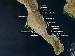
| Satellite map showing the islands in the southern Gulf of California | ||
| Waters | Gulf of California | |
| Geographical location | 25 ° 57 ′ N , 111 ° 10 ′ W | |
|
|
||
| length | 32 km | |
| width | 12 km | |
| surface | 145.937 km² | |
| Highest elevation | 479 m | |
| Residents | uninhabited | |
| main place | (Bahía Salinas) | |
Isla Carmen is a Mexican island in the southern Gulf of California . Administratively it belongs to the municipality ( municipio ) Loreto in the state of Baja California Sur ("Southern Baja California ").
geography
Isla Carmen is 10 miles east of Loreto , the capital of the parish on the Baja California Peninsula ; the southern tip of the island, Punta Baja , is only 9 km off the coast of the peninsula. The mountainous island is 32 km long, up to 12 km wide and reaches a height of 479 m above sea level. With an area of 146 km², it is the second largest island in the state after Isla San José . At Punta Arena , the southwestern tip of the island, there is a 10 m high lighthouse. The neighboring island of Danzante, which is significantly smaller with an area of 4 km², is around 2 km from there . In the northeast of the island is a once for salt production used lagoon . Not far from the lagoon, on the Bahía Salinas, is the abandoned settlement of the same name with a pier from which the salt was once shipped. Today there is the biological station Estación de Monitoreo Biologico OVIS of the Organización Vida Silvestre AC (OVIS) based in Monterrey . On the Bahía Ballandra in the northwest of the island there was another settlement with Puerto Ballandra . The now uninhabited island is part of the Bahía de Loreto National Park , which was proclaimed in July 1996, as well as - with 243 other islands - the UNESCO World Natural Heritage "Islands and Protected Areas in the Gulf of California" ( Spanish Islas y áreas protegidas del Golfo de California ).
Web links
Individual evidence
- ↑ UNEP Islands Directory (English)
- ↑ a b Sailing Directions (enroute), Pub. 153 (PDF; English; 3.3 MB) (Accessed January 11, 2011)
- ↑ Proclamation of the Parque Nacional Bahia de Loreto ( Memento of the original dated November 1, 2004 in the Internet Archive ) Info: The archive link was inserted automatically and has not yet been checked. Please check the original and archive link according to the instructions and then remove this notice. (PDF, Spanish)
- ↑ Entry on the website of the UNESCO World Heritage Center ( English and French ).

