Isla Santa Cruz (Mexico)
| Santa Cruz | ||
|---|---|---|
|
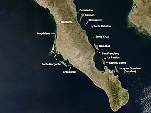
Satellite map with the islands in the southern Gulf of California Santa Cruz roughly in the middle |
||
| Waters | Gulf of California | |
| Geographical location | 25 ° 17 ′ 6 ″ N , 110 ° 43 ′ 0 ″ W | |
|
|
||
| length | 6.8 km | |
| width | 2.8 km | |
| surface | 12.896 km² | |
| Highest elevation | 457 m | |
| Residents | uninhabited | |
Isla Santa Cruz is a Mexican island in the southern Gulf of California . Administratively it belongs to the municipality ( municipio ) Loreto in the state of Baja California Sur ("Southern Baja California ").
geography
The island is located 21 km east of the Baja California peninsula and almost 100 km southeast of Loreto , the main town of the municipality. Neighboring larger islands are Santa Catalina 30 km away in the north and San José 20 km away in the south. The closest island, however, is Isla San Diego, 6 km off the southeast coast and only 0.6 km² in size . Santa Cruz is 6.8 km long, up to 2.8 km wide and has an area of just under 12.9 km². The mountainous, arid and uninhabited island reaches a height of 475 m above sea level. Isla Santa Cruz does not belong to the Bahía de Loreto National Park, which was founded in 1996, but - with 243 other islands - is part of the UNESCO World Heritage "Islands and Protected Areas in the Gulf of California" ( Spanish Islas y áreas protegidas del Golfo de California) ).
Web links
Individual evidence
- ↑ Sailing Directions (enroute), Pub. 153 (PDF (2.49 MB); English) (Accessed January 18, 2011)
- ↑ Entry on the website of the UNESCO World Heritage Center ( English and French ).

