Islas Año Nuevo
| Islas Año Nuevo | ||
|---|---|---|
| In the south Isla de los Estados , north of the land mass the Islas Año Nuevo | ||
| Waters | Atlantic Ocean | |
| Geographical location | 54 ° 39 ′ S , 64 ° 8 ′ W | |
|
|
||
| Number of islands | 5 | |
| Main island | Observatorio | |
| Total land area | 6 km² | |
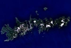
The Islas Año Nuevo ( New Year's Islands ) are an uninhabited, rocky group of islands north of Isla de los Estados and east of Isla Grande de Tierra del Fuego . It is located in the extreme southeast of Argentina , belongs to Tierra del Fuego and is administratively part of the city and district of Ushuaia in the Argentine province of Tierra del Fuego . The archipelago was named by James Cook , who reached it on January 1, 1775. He crossed Le Maire StreetHeading east in search of a safe haven. Cook was drawn to the marine fauna he found there and named his anchorage New Year's Harbor , which later became the name for the archipelago.
The Año Nuevo archipelago includes five flat, low-lying islands: Observatorio , Elizalde , Zeballos , Alférez Gofre and Gutiérrez . The islands' coastlines are rocky and lined with reefs and the surfaces are sparsely vegetated. Most of the soil consists of peat.
Except for Observatorio, the islands are inaccessible to humans. They are home to large penguin colonies , cormorants and marine mammals such as the maned seal or the southern elephant seal . In the 20th century, the archipelago served as a refuge for prisoners who had escaped from the prison on Isla de los Estados. Since the islands do not allow permanent life, many of them were later found dead there. The archipelago was placed under protection as the Isla de los Estados y Archipiélago de Año Nuevo nature reserve and may only be entered by authorized and regulated groups of visitors.
Isla Observatorio
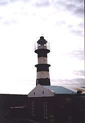
A lighthouse was built on Isla Observatorio in 1884 to facilitate the difficult navigation when circumnavigating Cape Horn . It was the first lighthouse Argentina built at sea. In 1901, the 21.7 m high lighthouse Faro Año Nuevo 3, a replacement for the first tower, was built and put into operation. Along with the new lighthouse, a magnetic observatory and various meteorological facilities were built at the request of the Royal Geographical Society of London. Additional buildings such as houses and warehouses were also built. Except for the lighthouse, the facilities were shut down in 1917, as sea traffic fell sharply after the opening of the Panama Canal in 1916. The Año Nuevo lighthouse was declared a National Historic Monument by Decree No. 64 of 1999. It's still working.
Access to the island of Observatorio is now regulated. Only tourists arriving from the city of Ushuaia and spending the night on the boat are allowed onto the island. There is a surveillance and maritime traffic control post of the Argentine Navy on the island . Years ago Observatorio served as a base for expeditions on the way to the Antarctic continent due to its strategic location .
Individual evidence
- ↑ John Cawte Beaglehole: The Life of Captain James Cook . A. and C. Black Ltd., Wellington 1974, p. 427.
- ^ Report of the WWF Reserva Provincial SuPatrimonio Natural y Cultural Isla De Los Estados (PDF; 4.6 MB) p. 16, Spanish, accessed on December 28, 2021.
- ^ A b Eva Paris: Tres islas llamadas Año Nuevo en el mundo. In: diariodelviajero.com. Diario del Viajero, 2020, accessed December 27, 2021 (Spanish).
- ↑ Isla Observatorio, Argentina - Geographical Names, map, geographic coordinates. In: geographic.org. Retrieved December 27, 2021 .
- ↑ Isla Observatorio in Provincia de Tierra del Fuego (PDF) ( Memento from May 31, 2011 in the Internet Archive )


