Itzling (Erding)
|
Itzling (Erding)
Municipality of Erding
Coordinates: 48 ° 16 '53 " N , 11 ° 52' 50" E
|
||
|---|---|---|
| Height : | 483 m above sea level NHN | |
| Residents : | 68 (2017) | |
| Postal code : | 85435 | |
| Area code : | 08122 | |
|
Location of Itzling (Erding) in Bavaria |
||
|
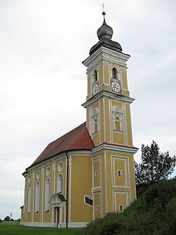
St. Vitus by Anton Kogler, from 1713
|
||
Itzling is a district of the city of Erding in Upper Bavaria in the Altenerding district .
location
The church village is located about four kilometers southwest of Erding and about 400 meters south of the federal highway 388 . The Itzlinger Graben flows through the village .
Architectural monuments
In the village is the church of St. Vitus by Anton Kogler , which was built from 1713.
Web links
Commons : Itzling - collection of images, videos and audio files
- Itzling in the location database of the Bayerische Landesbibliothek Online . Bavarian State Library


