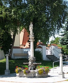
Altenerding
|
Altenerding
City of Erding
|
|
|---|---|
| Coordinates: 48 ° 17 ′ 35 ″ N , 11 ° 54 ′ 19 ″ E | |
| Height : | 466 m above sea level NN |
| Residents : | 8196 (2012) |
| Incorporation : | May 1, 1978 |
| Postal code : | 84435 |
Altenerding is a district of the large district town of Erding . Until the municipal reform in 1978, Altenerding formed its own municipality.
geography
Altenerding borders the core town of Erding to the south.
history
In 788 the settlement "Ardeoingas" was first mentioned in a document. In 891 King Arnulf donated the royal court there to the cathedral chapter in Salzburg . The place name is derived from the personal name Ardeo and referred to Altenerding before the ducal city of Erding was founded in 1228. The core of the late Gothic parish church of St. Mariae Annunciation was built by Anton Kogler 1721–1724. Altenerding had been the seat of a Hofmark since 1483 , which was temporarily owned by the Counts of Haag and later belonged to the Bavarian nursing court Erding . The community of Altenerding came into being with the community edict of 1818. The former community last included Altenerding, Ammersdorf , Aufhausen , Bergham , Graß , Indorf , Itzling , Kiefing , Klettham , Neuhausen , Pretzen , Schollbach , Singlding , Straß , Voggenöd , Werndlfing and Ziegelstatt . The place Sankt Paul originally belonged to the municipality Altenerding, from which he moved to Erding between 1885 and 1900 . Until the 1885 census, a wasteland Wasenstatt was listed as a place. Until 1924 Heilig Blut (Erding) belonged to the community. On May 1, 1978, the municipality was incorporated into the city of Erding as part of the municipal reform.
Individual evidence
- ↑ erding.de: data & statistics
- ↑ List of monuments for Erding (PDF) at the Bavarian State Office for Monument Preservation
- ^ Bavarian State Statistical Office (ed.): Official place directory for Bavaria . Issue 335 of the articles on Bavaria's statistics. Munich 1973, DNB 740801384 , p. 19 ( digitized version ).
- ↑ a b K. Bayer. Statistical Bureau (Ed.): Localities directory of the Kingdom of Bavaria. According to government districts, administrative districts, ... then with an alphabetical register of locations, including the property and the responsible administrative district for each location. LIV. Issue of the contributions to the statistics of the Kingdom of Bavaria. Munich 1888, Section III, Sp. 75 ( digitized version ).
- ↑ a b K. Bayer. Statistical Bureau (Ed.): Directory of localities of the Kingdom of Bavaria, with alphabetical register of places . LXV. Issue of the contributions to the statistics of the Kingdom of Bavaria. Munich 1904, Section II, Sp. 88 ( digitized version ).
- ↑ Bavarian State Office for Statistics and Data Processing (Hrsg.): The municipalities of Bavaria according to the territorial status May 25, 1987. The population of the municipalities of Bavaria and the changes in the acquisitions and territory from 1840 to 1987 (= contributions to Statistics Bavaria . Issue 451). Munich 1991, p. 44 , urn : nbn: de: bvb: 12-bsb00070717-7 ( digitized version - Landkreis Erding, footnote 3).
- ^ Federal Statistical Office (ed.): Historical municipality directory for the Federal Republic of Germany. Name, border and key number changes in municipalities, counties and administrative districts from May 27, 1970 to December 31, 1982 . W. Kohlhammer, Stuttgart / Mainz 1983, ISBN 3-17-003263-1 , p. 573 .


