Jewish cemetery (Tučapy u Soběslavi)

The Jewish cemetery in Tučapy u Soběslavi (German Tutschap), a municipality in the Okres Tábor district of the Jihočeský kraj region in the Czech Republic , was probably established in 1713.
location
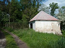
The Jewish cemetery is on the southwestern edge of the community, about 300 meters from the synagogue. The well-preserved cemetery has an area of 2356 m², on which there are about 360 mazewot (tombstones), the oldest from 1737. The tombstones made of marble, sandstone, limestone and granite are partially embedded in a wall that surrounds the cemetery. Inscriptions in Czech, Hebrew and German can be found on the tombstones. The cemetery also includes a former tahara house (morgue), where the entrance to the cemetery is today.
history
The cemetery was probably built around 1713; the oldest surviving tombstone with a legible inscription dates from 1737. There were plenty of burials until the outbreak of the Second World War.
In recent times there have been more extensive renovations: 1999–2001 the first wall sections were repaired, 2002–2003 the morgue, 2004–2007 further wall sections, 2010–2012 the lying tombstones were erected again and in 2014 a last section of the Muer was restored. Historical gravestones from the 18th and 19th centuries have been gradually renovated since 2015.
The cemetery has been a listed building since May 3, 1958.
Individual evidence
- ↑ a b Jiří Fiedler: Židovské památky v Čechách a na Moravě , keyword Tučapy , online at: holocaust.cz / ...
- ↑ Židovské památky , brief information from the official Tučapy website, online at: tucapy.cz/...3716
- ↑ a b c židovský hřbitov ÚSKP 45797 / 3-5081 in the monument catalog pamatkovykatalog.cz (Czech).
- ↑ Tucapy: Tabor, Bohemia , material of the International Jewish Cemetery Project, online at: iajgsjewishcemeteryproject.org / ...
See also
Web links
- Official website on tucapy.cz/
Coordinates: 49 ° 17 ′ 13.4 ″ N , 14 ° 48 ′ 6 ″ E

