
Jogashima
| Jogashima | ||
|---|---|---|
 |
||
| Waters | Pacific Ocean | |
| Geographical location | 35 ° 8 '0 " N , 139 ° 37' 15" E | |
|
||
| length | 2 km | |
| width | 800 m | |
| surface | 99 ha | |
| Highest elevation | 29.8 m | |
| Residents | 579 (April 2008) 585 inhabitants / km² |
|
| main place | Misakimachi-Jogashima | |

Jōgashima ( Japanese 城 ヶ 島 ) is a Japanese island off the Miura Peninsula .
geography
The 0.99 km² island is located in the Pacific Ocean at the southeast end of Sagami Bay . The easternmost point is Cape Awa-zaki ( 安 房 崎 ; 35 ° 7 ′ 45 ″ N , 139 ° 37 ′ 49 ″ E ) and the westernmost point is Cape Nagatoro-saki ( 長 津 呂 崎 ; 35 ° 8 ′ 5.5 ″ N , 139 ° 36 ′ 30 ″ E ).
The island has a flat profile, so that the highest point in the center of the island is 29.8 m. The south coast is surrounded by reefs and shaped by cliffs on which the Japanese cormorant and the reef freon nest.
Administratively, Jōgashima belongs to the municipality of Miura on the opposite Miura Peninsula, connected since 1960 by the Jōgashima Bridge ( 城 ヶ 島 大橋 , Jōgashima-ōhashi ) and forms a natural breakwater for the port of Misaki on the peninsula. The island forms the district of Misakimachi-Jōgashima and had 579 inhabitants in April 2008.
The headland to Cape Awa-zaki forms the 14.6 hectare Jōgashima Park ( 城 ヶ 島 公園 , Jōgashima kōen ), which is a popular destination at this time of year because of its 100,000 blooming daffodils between January and February.
history
In 1648 the commissioner for Misaki Abe Jirobei had a smoke signal set up for ship navigation at Awa-zaki on behalf of the Tokugawa Shogunate , but it was switched off again in 1678 and instead a fire signal based on oil lamps was set up at the western end of the island. In 1721 this was replaced by wood firing. On August 12, 1870, the lighthouse Jōgashima designed by French engineers was built in its place, which was the second nationwide with white light. This was badly damaged in the Great Kanto earthquake in 1923 and could not be put into operation again until 1926. In 1962 another lighthouse followed at Cape Awa-zaki.
Since the island was the waypoint of the shipping routes into the Bay of Tokyo with the seat of the shogunate in Edo ( Tokyo ), it formed an important element in the Japanese coastal defense, so that in 1808 the commissioner of Uraga ( Uraga bugyō ) had coastal batteries built on Jōgashima. The defense and fortifications were dismantled after the Second World War .
In 1913 the poet Kitahara Hakushū immortalized the island in his poem Jōgashima no ame ( 城 ヶ 島 の 雨 ), which was set to music by Yanada Tadashi, and in 1950 by Shigeo Tanaka and 1959 by Inomata Katsuto.
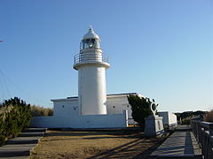
Jogashima lighthouse

Awazaki lighthouse

Memorial stone to Jōgashima no ame

Umanose dōmon ( 馬 ノ 背 洞門 )

Web links
Individual evidence
- ↑ a b 城 ヶ 島 (じ ょ う が し ま) . In: 日本 の 島 へ 行 こ う . Retrieved August 13, 2015 (Japanese).
- ↑ a b c d e f 城 ヶ 島 . In: 日本 大 百科全書 at kotobank.jp. Retrieved August 13, 2015 (Japanese).
- ↑ Official topographic map of Kokudo Chiriin
- ↑ 城 ヶ 島 公園 . Kanagawa Prefecture, May 15, 2015, accessed August 13, 2015 (Japanese).
- ↑ 城 ヶ 島 灯台 | 旅行 観 光 旅 国内 13 万 件 の 全国 観 光 情報 検 索 サ イ ト ト 全国 観 る な び 三浦 市 . In: miru-navi. Japan Travel and Tourism Association, accessed August 13, 2015 (Japanese).
- ↑ 安 房 崎 と 安 房 埼 灯台 (神奈川 県) . In: 岬 と 灯台 写真 館 . Retrieved August 13, 2015 (Japanese).