Jaigaon
| Jaigaon | ||
|---|---|---|
|
|
||
| State : |
|
|
| State : | West Bengal | |
| District : | Alipurduar | |
| Location : | 26 ° 52 ' N , 89 ° 23' E | |
| Height : | 209 m | |
| Residents : | 42,254 (2011) | |
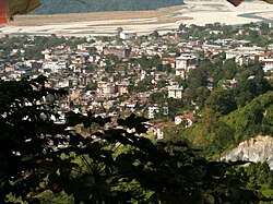
| View from Gumba Hill to Jaigaon | ||
Jaigaon (also Jaygaon , Jaygon or Jaigon ; Bengali : জয়গাঁ , Jaẏgā̃ ) is a city in the Indian state of West Bengal on the border with the Himalayan kingdom of Bhutan with about 40,000 inhabitants (2011 census). Jaigaon and the Bhutanese town of Phuentsholing actually form a joint city on the left bank of the Torsa River . Jaigaon is located in the Alipurduar district , which was separated from the Jalpaiguri district on June 25, 2014 and newly established .
From India, Jaigaon can be reached by bus from Shiliguri, 160 kilometers away, and also from Darjiling or Kalimpong on a continuously paved road.
The border between the two neighboring countries can be crossed within the urban area by Indians and Bhutanese without border formalities.
For non-Indian tourists, the Jaigaon / Phuentsholing border crossing is the only way to enter Bhutan besides the flight to Paro in Bhutan.
Demographics
At the 2001 census, the population was 38,664. Of these, 52% are male and 48% are female. 16% of the population are younger than 6 years. The literacy rate is 52% (men 59%, women 43%), below the national rate of 59.5%.


