Kalimpong
| Kalimpong | ||
|---|---|---|
|
|
||
| State : |
|
|
| State : | West Bengal | |
| District : | Darjiling | |
| Sub-district : | Kalimpong | |
| Location : | 27 ° 4 ′ N , 88 ° 28 ′ E | |
| Height : | 1152 m | |
| Residents : | 49,403 (2011) | |
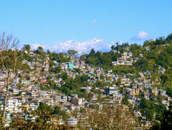
| View of Kalimpong | ||
Kalimpong ( Bengali : কালিম্পং , Kālimpaṃ ) is a city in the Siwaliks in the Indian state of West Bengal in the Darjiling district .
The place has about 50,000 inhabitants (2011 census). There is a large base of the Indian armed forces on the outskirts.
Kalimpong is known for its educational institutions far beyond the borders of West Bengal. For several years now, the place has also become interesting for tourism. There are many Buddhist temples here.
geography
The city is located on the mountains Deolo Hill and Durpin Hill in the Siwaliks at an average altitude of 1247 m above sea level. NN . Deolo, the highest point of the place, is at 1704 m. The Tista River near Kalimpong forms the border with the state of Sikkim .
history
For a long time the place was populated by the indigenous people of the Lepcha as well as the immigrant Bhutia and Limbu (weakly). Until the middle of the 19th century, the area was alternately ruled by the kingdoms of Sikkim and Bhutan . By the Treaty of Sinchula (1865) the area east of the Tista was added to the British East India Company . At that time, Kalimpong was a hamlet with four families. After the Duar War in 1864, Kalimpong was built as a mountain station by the British. It provided a retreat from the hot lower lying areas. Kalimpong's proximity to the Nathu La and Jelep La passes , offshoots of the Silk Road , became an advantage for foreign trade to Tibet and the rest of India.
The arrival of Scottish missionaries resulted in the building of schools, among other things. The Scottish University Mission Institution was the first in 1886, followed by the Kalimpong Girls High School. In 1911 the population was 7,880.
After Indian independence in 1947, Kalimpong became part of West Bengal after Bengal was split into an Indian and Pakistani part. With the annexation of Tibet by China in 1959, many Buddhist monks fled to the temples of Kalimpong, and since then they have also built many new monasteries.
The Gandhi Ashram School has existed since 1993 .
economy
The main industry is tourism , the high season is spring and summer. Agriculture, whose fields are laid out in terraces, is another important branch of the economy. Oranges and tea in particular grow here . The military installations also offer a sales market.
traffic
The nearest airport is Bagdogra Airport at Shiliguri (80 km), the nearest railway connection is in New Jalpaiguri about 10 kilometers south of Shiliguri. Kalimpong is on National Highway 31-A, which connects Shiliguri with Gangtok .
Culture
In the village there is the Lepcha Museum, which provides information about the Lepcha culture , and the Zang Dhok Palri Phodong Monastery with 108 volumes of the Kangyur . The monastery belongs to the Gelugpa School of Buddhism.
The Tibetan Tulku Dhardo Rinpoche lived here from 1954 until his death in 1990. He is an example of the many refugees who settled here.
Kalimpong is currently the main residence of Thaye Dorje , who is contesting Orgyen Thrinle Dorje 's claim to be the 17th Karmapa .
literature
- Markus Viehbeck (Ed.): Transcultural Encounters in the Himalayan Borderlands: Kalimpong as a “Contact Zone” (= Heidelberg Studies on Transculturality. Volume 3). Heidelberg University Publishing, Heidelberg 2017, DOI: 10.17885 / heiup.301.409 ( digitized version ).
Web links
(each in English)
- Govt. of West Bengal official site feat. Kalimpong
- Information on Kalimpong from Darjeelingnews.net
- Kalimpong News and Information
- Kalimpong


