
Nathu La
| Nathu La | |||
|---|---|---|---|
 Pass height |
|||
| Compass direction | south | North | |
| Pass height | 4545 m | ||
| region | Sikkim State (India) | Tibet Autonomous Region | |
| Valley locations | Gangtok | Qiemacun | |
| expansion | Pass road | ||
| Mountain range | Himalayas | ||
| profile | |||
| Ø pitch | 4.5% (2765 m / 62 km) | ||
| map | |||
|
|||
| Coordinates | 27 ° 23 '12 " N , 88 ° 49' 53" E | ||

| Tibetan name |
|---|
|
Tibetan script :
རྣ་ ཐོས་ ལ་
|
|
Wylie transliteration : rna thos la
|
|
Official transcription of the PRCh : Natoi La
|
|
THDL transcription : Natö La
|
|
Other spellings: Nathö La
|
| Chinese name |
|
Simplified :
乃 堆 拉
|
|
Pinyin : Nǎiduī Lā
|
Nathu La ( Natoi La ; also Nathula ; Nepali : नाथू ला, ) is a mountain pass on the Indo - Tibetan border that connects the Indian state of Sikkim with the autonomous region of Tibet ( China ). It was part of the southern route of the Silk Road , but was closed in 1962 as a result of the Sino-India border war . In July 2006 the pass was reopened.
geography
The Nathu La Pass is located 56 km east of Sikkim's capital Gangtok at an altitude of 4545 m and is about 460 km from the Tibetan capital Lhasa and 550 km from the Indian port city of Kolkata . Unlike the Jelep La Pass , which is only 5 km away , the Nathu La Pass is not passable in winter, as heavy snowfalls and temperatures below −25 ° C are common.
The road from Gangtok to Nathu La, which is one of the highest drivable roads in the world, is particularly scenic. The vegetation changes from subtropical forests to alpine climates to tundra and cold desert in the high mountains. On the Chinese side, the path continues to the Chumbi Valley in the Tibetan highlands .
history
Nathu La was already used in ancient times as a junction of the Silk Road that connected Lhasa with the Bengali plain . After the British annexed areas of Sikkim, Nepal and Bhutan in 1815 , trade across the pass increased significantly. In December 1893, a trade agreement between the Kingdom of Sikkim and Tibet was concluded, which guaranteed the flow of goods over the Nathu La.
In September 1904, the British colonial rulers signed an agreement with Tibet that gave the British not only access to the Chumbi Valley, but also the establishment of trading posts in the Tibetan cities of Gyangzê and Gartok. This contract was enforced by the British under massive pressure after the British explorer and officer Francis Younghusband expelled the 13th Dalai Lama Thubten Gyatso in the British Tibet campaign and took the capital Lhasa. Subsequent negotiations confirmed China's sovereignty over Tibet, and in November 1904 the British concluded a trade agreement with China.
In the early 1950s, the newly established People's Republic of China took more and more control of Tibet. This led to a popular uprising in 1959, which was bloodily suppressed. At that time, the Nathu-La Pass served as an escape route for many Tibetans. However, as a result of the Indo-Chinese border war , in which Nathu La was the scene of several skirmishes between the warring troops, the pass and other border crossings between India and China were closed in 1962.
Only after more than twenty years did the two countries come closer to each other. In 1992 it was suggested that the Lhasa Kalimpong connection be reopened . But it took another eleven years before official talks about a possible border opening began. These talks finally came to a conclusion in 2004 and it was agreed that Nathu La would open in October 2005. Organizational problems on the part of China delayed the ceremonial opening of the border until July 6, 2006. Official representatives from both countries and 100 traders each from India and Tibet were present at the opening of the passport, who were resuming trade relations between the two regions by crossing the border .
In 2009 the first land data cable was laid between India and China via the Nathu La.
On June 22, 2015, China opened the border for Indian pilgrims who want to go to Kailash and Manasarovar Lake. In the first year 250 pilgrims in five groups of 50 people each are expected at the border. The opening of the border saves pilgrims having to cross the 5200 m high Qang La Pass and shortens the journey from 20 days to 12 days.

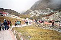
Information sign at the Nathu La Pass
Nathu La near the Sino-Indian border

Nathu La as seen from Kalimpong


Web links
Individual evidence
- ↑ 国家 测绘 局 地名 研究所(Ed.):西藏 地名/ བོད་ ལྗོངས་ ས་ མིང . Beijing:中国 藏 学 出版社, 1995, p. 337.
- ↑ Kirstin Wenk: China and India walk the paths of the Silk Road . In: Die Welt , July 7, 2006
- ↑ Werner Pluta: Digital Silk Road through the Himalayas . In: Golem , August 31, 2009.
- ↑ China Focus: China opens new route for Indian pilgrims to Tibet at: Xinhua News , June 22, 2015, accessed June 22, 2015