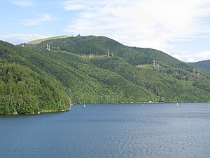
Jezioro Międzybrodzkie
| Jezioro Międzybrodzkie | |||||||||||
|---|---|---|---|---|---|---|---|---|---|---|---|
| With Żar in the background | |||||||||||
|
|||||||||||
|
|
|||||||||||
| Coordinates | 49 ° 47 ′ 18 ″ N , 19 ° 12 ′ 15 ″ E | ||||||||||
| Data on the structure | |||||||||||
| Construction time: | 1937 | ||||||||||
| Height of the barrier structure : | 37 m | ||||||||||
| Data on the reservoir | |||||||||||
| Altitude (at congestion destination ) | 320 m npm | ||||||||||
| Water surface | 3.8 km² | ||||||||||
| Storage space | 26.6 million m³ | ||||||||||
The Jezioro Międzybrodzkie (German: Międzybrodzie-See ) is a reservoir on the Soła , in the Polish Voivodeship of Silesia . It is located in the Soła Gorge through the Lesser Beskids mountain range . The Jezioro Żywieckie reservoir is located upstream and the Jezioro Czanieckie reservoir downstream .
description
Behind the 37 m high dam the water which is Soła and smaller tributaries dammed. When the reservoir is completely blocked, it contains 26.6 million m³ of water. The water area is then 3.8 km².
history
Construction took place in 1937 and the reservoir was flooded in the same year. It is used as a fresh water reservoir for Bielsko-Biała .
tourism
The lake is open to tourists, there are beaches and marinas.
Web links
Commons : Lake Międzybrodzie - collection of images, videos and audio files
literature
- Barański Mirosław: Pasmo Baraniej Góry. Przewodnik turystyczny, Wydawnictwo PTTK "Kraj", Warszawa 1999
panorama

View from Czupel in the Little Beskids


