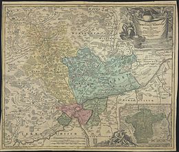
Johann Christoph Lauterbach (cartographer)
Johann Christoph Lauterbach (* 1675 ; † October 20, 1744 in Ulm ) was a German cartographer and engineer officer who worked in the Free Imperial City of Ulm.
Family relationships
Johann Christoph Lauterbach's family came from the craftsman class. His father Johann Lauterbach (1640–1719) was a Schumacher and guild master in Ulm. His mother Veronika Heckenauer (1644–1729) was Johann's second wife. The mathematician and architect Johann Balthasar Lauterbach (1663–1694) came from the father's first marriage and was thus a half-brother of Johann Christoph.
Fields of activity
Johann Christoph Lauterbach's work was very diverse. In addition to his cartographic work, he has also worked as an armory clerk and architect (master builder).
His most important cartographic work was a map of the Ulm area ( Nova et accurata Territorii Ulmensis cum Dominio Wainensi ), which was engraved in copper by Johann Baptist Homann (1664–1724) and published in Nuremberg in 1720 . (Forerunners of this map, also based on drafts by Lauterbach, were an etching by Homann in 1709 and another etching by Gabriel Bodenehr in 1710 [1664 / 73–1758 / 65].) Lauterbach map material by Wolfgang Bachmeyer (1597– 1685), who carried out the first land surveys in the ulmian areas in the 17th century and whose work was defining mapping there for almost a century. Bachmeyer's maps were often copied and engraved. Of all these follow-up cards, Johann Christoph Lauterbach's card from 1720 in its extensive revision was the best known and probably the most beautiful. In any case, the map historian Eberhard David Hauber (1695–1765) praised the aesthetics of this work: And this chart is absolutely beautiful, and illumiret in a particularly pleasant way.
Other cartographic work by Johann Christoph Lauterbach included recordings of rivers, which he depicted in several colored ink drawings. For example, in 1708 a blueprint (33 × 50 cm) with the grinding, grinding, hammer and sawmills adjacent to it and with dimensions of the gradient and the width of the hydraulic engineering entrances. In 1712 a plan of the course of the Iller near Unterkirchberg (32 × 40.5 cm) with bridges was created and in 1727 a plan of the mouth of the Iller (33 × 42 cm) with battles and wing battles, dimensions, cost and material proposals and explanations.
literature
- Uwe Schmidt: History of technology in the imperial city of Ulm. Subject inventory (= research on the history of the city of Ulm, series of documentations. Volume 9). Kohlhammer, Stuttgart 1995
- Ruthardt Oehme: The history of the cartography of the German southwest. With 16 color plates and 42 black-and-white maps. Thorbecke, Konstanz / Stuttgart 1961
- Eberhard David Hauber: An attempt at a complicated history of the country charts, both of which country charts in general, the same first origin, their nature, different genres, various uses, still having errors, and necessary improvements, with the related writings; As well as of those country charts of each country in particular, their quality and advantages, and how they most appropriately can be used and illuminated: Besides the testimonies of old and new scribes, and other good reasons collected; And in addition to a historical message of which country charts of the Swabian Craisses, the Duchy of Wurttemberg, as well as other rulers located in Swabia, are given out with various comments. Daniel Bartholomäi, Ulm 1724 ( digitized version )
Web links
- Literature by and about Johann Christoph Lauterbach in the bibliographic database WorldCat
- Bayerische Staatsbibliothek The map Nova et accurata Territorii Ulmensis cum Dominio Wainensi in a different reproduction
Remarks
- ↑ Ruthardt Oehme: The history of the cartography of the German Southwest (1961), page 101
- ↑ Eberhard David Hauber: An attempt at a complicated history of the country charts (1724), page 158
- ^ Uwe Schmidt: History of technology in the imperial city of Ulm (1995), page 146
- ^ Uwe Schmidt: History of technology in the imperial city of Ulm (1995), page 93
- ^ Uwe Schmidt: History of Technology in the Imperial City of Ulm (1995), page 121
| personal data | |
|---|---|
| SURNAME | Lauterbach, Johann Christoph |
| ALTERNATIVE NAMES | Lauterbach, Johannes Christophoro; Lauterbach, Johannes Christophoros |
| BRIEF DESCRIPTION | German cartographer and engineer officer |
| DATE OF BIRTH | 1675 |
| DATE OF DEATH | October 20, 1744 |
| Place of death | Ulm |

