Kísilvegur
| Main Road 87 Iceland |
||||||||||||||||||||||||||||||||||||||||
| Kísilvegur | ||||||||||||||||||||||||||||||||||||||||

|
||||||||||||||||||||||||||||||||||||||||
| map | ||||||||||||||||||||||||||||||||||||||||
| Basic data | ||||||||||||||||||||||||||||||||||||||||
| Operator: | Vegagerðin | |||||||||||||||||||||||||||||||||||||||
| Start of the street: |
Hringvegur ( 65 ° 40 ′ N , 16 ° 59 ′ W ) |
|||||||||||||||||||||||||||||||||||||||
| End of street: |
Norðausturvegur ( 65 ° 58 ′ N , 17 ° 23 ′ W ) |
|||||||||||||||||||||||||||||||||||||||
| Overall length: | 42.11 km | |||||||||||||||||||||||||||||||||||||||
| Development condition: | asphalted | |||||||||||||||||||||||||||||||||||||||
|
Course of the road
|
||||||||||||||||||||||||||||||||||||||||
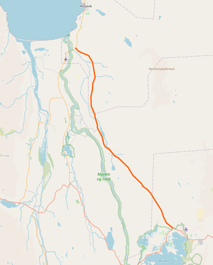
The Kísilvegur is a main road in the northeast of Iceland .
It connects the ring road ![]() at Myvatn with the Norðausturvegur
at Myvatn with the Norðausturvegur ![]() . Kieselguhr was extracted from the lake and processed in a plant in Reykjahlíð between 1966 and 2004 . The finished product was exported through Húsavík . This road was built in 1967 for this purpose. The Icelandic word kísill means pebble or silicon. The Icelandic word for kieselguhr is kísilgúr , or barnamold and pétursmold .
. Kieselguhr was extracted from the lake and processed in a plant in Reykjahlíð between 1966 and 2004 . The finished product was exported through Húsavík . This road was built in 1967 for this purpose. The Icelandic word kísill means pebble or silicon. The Icelandic word for kieselguhr is kísilgúr , or barnamold and pétursmold .
Now the Kísilvegur begins north of the lake, where the ring road branches off to the south. When the ring road ran south of the lake through the town of Skútustaðir , it was 4 km longer and led to Reykjahlíð. The Hólasandur is a sandy desert through which there have been paths in the past. The Þverá flows into the Langavatn lake, whose outflow is the Reykjakvísl. The Hvammavegur ![]() is 8 km long and bridges the Laxá í Aðaldal . Hveravellir, not to be confused with that in the Icelandic highlands , is the largest geothermal area in Reykjahverfi, to which Reykjavellir also belongs. From here, Húsavík is supplied with hot water via an 18 km long pipeline . The other rivers Helgá, Þverá and Skógaá are right tributaries of the Reykjakvísl, which becomes Mýrarkvísl and flows into the Laxá í Aðaldal. The entire length of Kísilvegur is paved and ends after 42 km at Norðausturvegur
is 8 km long and bridges the Laxá í Aðaldal . Hveravellir, not to be confused with that in the Icelandic highlands , is the largest geothermal area in Reykjahverfi, to which Reykjavellir also belongs. From here, Húsavík is supplied with hot water via an 18 km long pipeline . The other rivers Helgá, Þverá and Skógaá are right tributaries of the Reykjakvísl, which becomes Mýrarkvísl and flows into the Laxá í Aðaldal. The entire length of Kísilvegur is paved and ends after 42 km at Norðausturvegur ![]() .
.
See also
Individual evidence
- ↑ a b c Vegaskrá 2019 - kaflaskipt. Retrieved July 17, 2020 (Icelandic).
- ↑ Bundið slitlag á þjóðvegum 2019. Retrieved July 23, 2020 (Icelandic).
- ↑ Brúaskrá, bryr á þjóðvegum. Retrieved July 18, 2020 (Icelandic).
- ↑ a b Iceland Road Guide 1988, p. 318
