Künes (river)
|
Künes 巩乃斯 河 Gǒngnǎisī Hé |
||
|
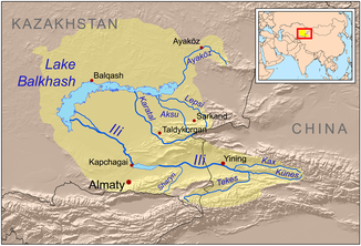
Course of the Künes in the catchment area of Lake Balchasch |
||
| Data | ||
| location | Xinjiang ( PR China ) | |
| River system | Ili | |
| Drain over | Ili → Lake Balkhash | |
| Headwaters | South flank of Irenchabirga ( Tian Shan ) 43 ° 12 ′ 35 ″ N , 84 ° 50 ′ 51 ″ E |
|
| Association with |
Tekes zum Ili Coordinates: 43 ° 34 ′ 45 " N , 82 ° 32 ′ 51" E 43 ° 34 ′ 45 " N , 82 ° 32 ′ 51" E
|
|
| length | 220 km | |
The Künes ( Chinese 巩乃斯 河 , Pinyin Gǒngnǎisī Hé ) is the right source river of the Ili in the Uyghur Autonomous Region of Xinjiang in the northwest of the People's Republic of China .
The Künes rises on the southern flank of the Irenchabirga in eastern Tian Shan . From there the river flows in a westerly direction through a wide high valley in the Künes district of the same name and after 220 km meets the Tekes coming from the south . In the summer months there are regular floods. Some of the water is diverted for irrigation purposes .
Individual evidence
- ↑ a b Article Kunges in the Great Soviet Encyclopedia (BSE) , 3rd edition 1969–1978 (Russian)
- ↑ 《中国 地 名录》

