Kax
|
Kax 喀什 河 / Kax He / Kasch |
||
|
|
||
| Data | ||
| location | Xinjiang ( PR China ) | |
| River system | Ili | |
| Drain over | Ili → Lake Balkhash | |
| Headwaters |
Irenchabirga (Eastern Tian Shan ) 43 ° 26 ′ 49 ″ N , 84 ° 55 ′ 21 ″ E |
|
| muzzle |
Ili coordinates: 43 ° 37 '39 " N , 81 ° 47' 48" E 43 ° 37 '39 " N , 81 ° 47' 48" E
|
|
| length | 350 km | |
| Catchment area | approx. 10,000 km² | |
| Drain |
MQ |
127 m³ / s |
| Reservoirs flowed through | Jilintai Dam | |
| Small towns | Nilka | |
|
Course of the Kax (Kasch) |
||
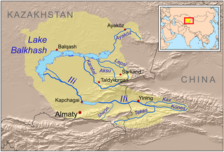
The Kax ( Chinese 喀什 河 , Pinyin Kāshí Hé ; Kax He ; also: Kasch ) is a right tributary of the Ili in the Uyghur Autonomous Region of Xinjiang in northwest China .
The Kax rises in the Irenchabirga , a mountain range of the eastern Tian Shan . It flows in the upper reaches in a longitudinal valley in a westerly direction through the Nilka district and flows into the Ili on the right after 350 km east of Gulja . The Kax drains an area of around 10,000 km². The river is mainly fed by the snowmelt and meltwater from the glaciers . In summer there are floods every year. The mean discharge (MQ) is 127 m³ / s. The highest discharge rates are over 700 m³ / s. The water of the Kax is used for irrigation . The Kax is dammed east of Nilka by the Jilintai Dam .
