Coastal settlement of Cala Morell
| Coastal settlement of Cala Morell Poblat de Cala Morell | ||
|---|---|---|
|
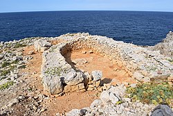
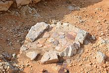
Naviform house in Cala Morell |
||
|
Location in Menorca |
||
| Coordinates | 40 ° 3 '27 " N , 3 ° 52' 56" E | |
| place | Ciutadella , Balearic Islands , Spain | |
| Emergence | 1600 to 1450 BC Chr. | |
| height | 35 m | |
The coastal settlement of Cala Morell ( Catalan Assentament costaner de Cala Morell or Poblat de Cala Morell ) is an archaeological site in the municipality of Ciutadella in the west of the Spanish Balearic island of Menorca . The Bronze Age settlement of naviform houses dates from the middle of the 2nd millennium BC. Chr.
location
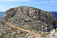
The site is located in the western part of the north coast of Menorca on the headland Es Coll de Cala Morell, which borders the bay of Cala Morell in the north. From the holiday complex of the same name, a path that ends in a stepped path leads up to the remains of the settlement. At a vantage point on this path, a display board provides information about the archeology of the site.
Another important site, the necropolis of Cala Morell , is located to the south at a distance of about 850 m.
Digs
In the mid-1990s, Gustau Juan and Lluis Plantalamor carried out an initial survey of the coastal settlement and identified a wall, thirteen residential buildings, two artificial water basins and a round structure of unknown function. As part of the research project “Entre Illes” (“Between the Islands”), which studies Bronze Age coastal settlements on Mallorca and Menorca, excavations have been carried out annually on the Coll de Cala Morell since 2011 under the direction of Montserrat Anglada. Two residential buildings, Naviformes 11 and 12, were uncovered and scientifically examined. Since 2015, the excavation work has concentrated on the round structure in the south.
description
The coastal settlement of Cala Morell is located on a rocky headland that is difficult to access at about 35 m above sea level. To the east it is protected by a stone wall.
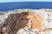
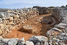
The houses found are Naviformes. This is a type of building made of double-walled dry masonry , which has an elongated horseshoe-shaped floor plan and ends in an apse . The entrance is always on the short side opposite the apse. The roofs of the Naviformes usually consisted of branches, small stones and earth. Most of the houses in the coastal settlement of Cala Morell face south or south-west. They are about eight meters long and up to three meters wide. The excavated Naviformes 11 and 12 belong to five houses that are lined up one behind the other on the eastern boundary wall. The preserved remains of the house walls are surprisingly high for the exposed site exposed to wind erosion and are layered of relatively small stones compared to other Naviformes, whose outer walls are made using the Cyclops technique. Inside Naviforme 11, a rectangular fireplace has been preserved, which is bordered by flat stone benches. In a niche that is formed from the walls of the two naviformes and the wall, there is a grinding stone on a small stone bench on the right in front of the house entrance , which allows the conclusion that grain was a food component of the previous residents. Bones from goats, sheep, pigs and cattle were found in the houses themselves. Despite the proximity of the sea, however, no remains of fish or mussels could be detected. In addition to pottery shards, small bone and stone tools such as awls were found.
Immediately west of Naviforme 12 there are two artificial depressions about eight by four meters in size, which are interpreted as reservoirs of rainwater. Further south, on the highest point of the headland, there is a circular building structure, the excavation of which began in October 2015. The assumption that it could have been a kind of landmark with the function of a lighthouse has not yet been substantiated by finds.
The results of radiocarbon analyzes on samples from Naviforme 11 were a surprise for the archaeologists. Before the excavations began, it was expected that one of the most recently built naviform settlements would be in front of them, the inhabitants of which, due to new developments in island society, were at the transition to the Prototalayotic ( in the 11th century BC) would have been marginalized. It turned out, however, that Naviforme 11 from the period between 1600 and 1450 BC And thus originated at the beginning of the naviform phase. This initially left the question unanswered as to why the settlement was built in this inhospitable place, far from pastures or farmland. The virtue of the location that it was easy to defend indicates social conflict in Bronze Age society.
Monument protection
The site is registered as a monument in the Spanish database of cultural assets ( Bienes de Interés Cultural ) under the number RI-51-0003363 .
The prehistoric settlement is one of the 32 archaeological sites that Spain officially proposed on January 14, 2016 as " Talayotic Culture of Menorca " for inclusion on the UNESCO World Heritage List . The World Heritage Committee postponed the application at its 41st meeting in July 2017 and requested improvements.
literature
- Antoni Nicolau Martí, Elena Sintes Olives, Ricard Pla Boada, Albert Àlvarez Marsal: Talayotic Minorca . The prehistory of the island. Triangle Books, Sant Lluís 2015, ISBN 978-84-8478-640-5 , pp. 300-303 (English).
- Gustau Juan, Lluis Plantalamor: L'aixecament planimètric del cap costaner de Cala'n Morell (Ciutadella-Menorca) . In: Treballs del Museu de Menorca . tape 15 , 1996 (Catalan).
- Montserrat Anglada Fontestad, Antoni Ferrer Rotger, Magdalena Salas Burguera, Damià Ramis Bernad: L'excavació arqueològica al cap costaner fortificat de cala Morell . In: ÀMBIT . tape 26 , 2012 (Catalan, cime.es [PDF; 635 kB ]).
- Montserrat Anglada, Antoni Ferrer, Damià Ramis, Magdalena Salas: Resultats preliminars del projecte Entre Illes - el cas dels jaciments de sa Ferradura (Manacor) i Cala Morell (Ciutadella) . In: M. Riera, J. Cardell (eds.): V Jornades d'Arqueologia de les Illes Balears, Palma, 28. – 30. September 2012 . Documenta Balear, 2013, p. 51-58 (Catalan).
- Montserrat Anglada, Maria José León, Damià Ramis, Magdalena Salas: Una estructura prehistòrica desconeguda al Cap costaner de Cala Morell . In: ÀMBIT . tape 39 , 2016, p. 4–9 (Catalan, cime.es [PDF; 4.8 MB ]).
Individual evidence
- ^ A b Gustau Juan, Lluis Plantalamor: L'aixecament planimètric del cap costaner de Cala'n Morell (Ciutadella-Menorca) , 1996 (Catalan).
- ↑ a b Montserrat Anglada et al .: Results preliminars del projecte Entre Illes - el cas dels jaciments de sa Ferradura (Manacor) i Cala Morell (Ciutadella) , 2013 (Catalan).
- ↑ a b c d Nicolau Martí et al .: Talayotic Minorca , 2015, pp. 286–299 (English).
- ↑ Cala Morell coastal settlement on the Menorca Talayótica website, accessed on December 11, 2016.
- ↑ a b c d Montserrat Anglada et al .: Una estructura prehistòrica desconeguda al Cap costaner de Cala Morell , 2016 (Catalan).
- ↑ Cultural heritage database at the Spanish Ministry of Education, Culture and Sport (note: search for “Es Coll de Sa Cala”), accessed on December 11, 2016.
- ↑ Talayotic Culture of Minorca , on the Spanish tentative list at UNESCO (English), accessed on October 28, 2017.
- ↑ World Heritage Committee (Ed.): List of nominations received by February 1, 2016 and for examination by the World Heritage Committee at its 41st session (2017) . (English, unesco.org [PDF; 427 kB ]).
- ↑ World Heritage Committee (Ed.): Decisions adopted during the 41st session of the World Heritage Committee (Krakow, 2017) . (English, unesco.org [PDF; 4.5 MB ]).
