
Kaiserstrasse (Trier)
| Kaiserstrasse | |
|---|---|
|
|
|
 |
|
| Basic data | |
| place | trier |
| District | center |
| Hist. Names | Schlageterstrasse |
| Connecting roads | St. Barbara Ufer , Ostallee |
| Cross streets | Neustraße , Hindenburgstraße , Lorenz-Kellner-Straße, Wallstraße, Weberbach |
| Buildings | Kaiserthermen |
The Kaiserstraße is a street in the old town of Trier . It runs between the Kaiserthermen in the east and the banks of the Moselle in the west. It is part of the Trier Alleenring and is only used as a one-way street in an east-west direction. The Südallee runs parallel and is only used in the opposite direction.
history
There are two ways of deriving the origin of the name: either the name is derived from a figure of the Roman Emperor Constantine standing on a high pillar at the end of the street on the banks of the Moselle , or it was chosen in memory of the German emperor's dignity that was restored in 1871. The upper part was named as early as 1895.
From 1933 to 1945 it was called Schlageterstraße .
Cultural monuments

In addition to some old remains of the former Trier city wall (including a defense tower) and the eastern front of the Kaiserthermen, there are 18 other cultural monuments from the 19th and early 20th centuries on the street. The buildings were mainly built in neoclassicism . One of the buildings is the Trier synagogue.
The stage - a former newspaper kiosk, located in the green belt at Neustraße, was redesigned into an exhibition space in 2009 by students of the courses in architecture and interior design at Trier University of Applied Sciences. The exhibits are visible from the outside through the windows and can therefore be admired regardless of opening times. Opposite is one of two inner city filling stations in Trier.

Junction Südallee / Kaiserstraße with Neustraße in the north and Saarstraße in the south

Bastion Südallee, part of the former city wall
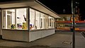
Art kiosk stage
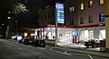
Esso petrol station in Südallee


literature
- Patrick Ostermann (arrangement): City of Trier. Old town. (= Cultural monuments in Rhineland-Palatinate. Monument topography Federal Republic of Germany . Volume 17.1 ). Wernersche Verlagsgesellschaft, Worms 2001, ISBN 3-88462-171-8 .
- General Directorate for Cultural Heritage Rhineland-Palatinate (publisher): Informational directory of cultural monuments of the district-free city of Trier . Koblenz 2010 ( gdke-rlp.de [PDF; 1,2 MB ; accessed on September 1, 2016]).
Individual evidence
- ^ A b Emil Zenz: Street names of the city of Trier: their sense and their meaning . Ed .: Culture Office of the City of Trier. 5th edition. Trier 2006, DNB 455807825 (first edition: 1961).
- ↑ Patrick Ostermann (arrangement): City of Trier. Old town. (= Cultural monuments in Rhineland-Palatinate. Monument topography Federal Republic of Germany . Volume 17.1 ). Wernersche Verlagsgesellschaft, Worms 2001, ISBN 3-88462-171-8 .
Coordinates: 49 ° 45 ′ 1.4 " N , 6 ° 38 ′ 8.1" E