Limestone island
The northern part of the Museum Island, separated by the Ludwigsbrücke, with the official name “Auf der Insel” was previously called the Kalkinsel in Munich . The name goes back to a lime kiln built in 1865 on its northern part in one of the five houses that have existed for a long time. In the city address book of 1880/81 it says as a preamble to the address "island on which":
"Among the people it is sometimes also called> Kalkinsel <, while the northern part of an eastern peninsula surrounded by the Isar and the Auermühlbach is called" Coal Island "."
The Kalkinsel has nothing to do with the neighboring Kalkofeninsel with the Müller'schen Volksbad , but is sometimes wrongly equated with it. On the southern part of the island at the Ludwigsbrücke there was originally a wooden garden (storage place for the wood delivered by rafts), later a military arsenal. In the 1930s, the city acquired the entire site and the buildings were gradually demolished.
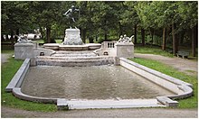
Today the (half) island is undeveloped except for the Father Rhine Fountain . The fountain system was designed in 1903 by Adolf von Hildebrand for Strasbourg . After the end of the First World War , however, it was dismantled there and came to the city of its creator, where it was unveiled in 1929.
The northern tip of the Limestone Island is connected to the Prater Island by a walkable, approximately 170 meter long weir footbridge .
Individual evidence
- ↑ Planning documents of the local building commission for the house "Auf der Insel" No. 5 in the Munich City Archives
- ↑ City address book from 1880/81 under "On the island"
- ↑ English city map "Munich" from 1832
literature
- Peter Klimesch: Isar lust. Discoveries in Munich. MünchenVerlag, Munich 2011, ISBN 978-3-937090-47-4 . (Therein chapter about the Munich Isar islands.)
- Peter Klimesch: Munich Isar Islands - Past, Present and Future. In: Ralf Sartori (ed.): The new Isar. Volume 4. Buch & Media, Munich 2012, ISBN 978-3-86520-447-9 .
Coordinates: 48 ° 7 ′ 57.8 " N , 11 ° 35 ′ 13.6" E
