Cape Astrup
| Cape Astrup | ||
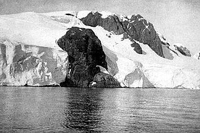
 photographed by Frederick Cook on the Belgica expedition (1897–1899) |
||
| Geographical location | ||
|
|
||
| Coordinates | 64 ° 43 ′ S , 63 ° 11 ′ W | |
| location | Wiencke Island , Palmer Archipelago | |
| Waters | Gerlache Street | |
| Waters 2 | Neumayer Canal | |
The Cape Astrup ( French Cap Eivind Astrup ) is a vivid, dark-colored cape , which is the northern end of the Wiencke Island in the Palmer Archipelago off the west coast of the Antarctic Peninsula marked. It forms the eastern boundary of the northern entrance from Gerlache Strasse into Neumayer Canal .
It was discovered during the Belgica expedition (1897–1899) led by the Belgian polar explorer Adrien de Gerlache de Gomery . He named it after the Norwegian polar explorer Eivind Astrup (1871–1895), participant in the Greenland expeditions Robert Edwin Pearys from 1891 to 1892 and from 1893 to 1895.
Web links
- Cape Astrup in the Geographic Names Information System of the United States Geological Survey (English)
- Cape Astrup on geographic.org (English)
