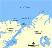
Cape Columbia
The Cape Columbia ( English Cape Columbia ) is the northernmost point of Canada and the American continent when this Greenland not impute. It is located on Ellesmere Island in the Canadian Arctic Archipelago at 83 ° 6 ′ 41 ″ N , 69 ° 57 ′ 30 ″ W 766.84 km from North Pole away. From Cape Columbia to the southernmost point of the American continent ( Cape Horn ) the distance is 15,485 km.

The cape was first reached by Lieutenant Pelham Aldrich , a participant in the British Arctic Expedition from 1875 to 1876 under George Nares .
As the northernmost mainland point of Canada, Cape Columbia is exposed to the ice drift of the Arctic pack ice. The approximately 2 meter thick pack ice of the Arctic Ocean moves several hundred meters per hour from east to west. As a result, mighty ridge of press ice can be piled up at Cape Columbia.
Individual evidence
- ^ William James Mills: Exploring Polar Frontiers - A Historical Encyclopedia . tape 2 . ABC-CLIO, 2003, ISBN 1-57607-422-6 , pp. 448 .


