
Kapuzinerinsel (Inn)
| Capuchin Island | ||
|---|---|---|
 |
||
| Waters | Inn | |
| Geographical location | 48 ° 3 '35 " N , 12 ° 13' 29" E | |
|
||
| length | 290 m | |
| width | 75 m | |
| surface | 1.48 ha | |
| Residents | uninhabited | |

The Kapuzinerinsel , formerly also known as Mittergries or Köhlerinsel , is a small wooded river island in the Inn near the Upper Bavarian town of Wasserburg am Inn with an area of around 1.5 hectares .
It is located just behind the Wasserburg run-of- river power plant and, when the water level is low , can be reached by foot through an artificially created guide dam that directs the water from the power plant back into the river. On the Kapuzinerinsel there is a small hardwood forest and on the side facing away from the river there is a sandy beach.
The name of the island is reminiscent of the monks of the Capuchin order who once resided here , who had to leave the Capuchin monastery and the city in the course of the Bavarian secularization .

Even when the water level is low, water always flows through the southern side of the island thanks to culverts in the dam and forms a network of small ponds and rivulets , the so-called " capuchin paints ". This area is equipped with many quiet zones and was artificially redesigned in 2010 to ensure the natural reproduction of grayling , an endangered species of fish. Since then, the gravel bottom of the Inn has been loosened every spring by an excavator, and a fish ladder is also planned over the barrage.
For years there have been plans to build a second Inn bridge to Wasserburg's old town especially for cyclists and pedestrians across the Capuchin Island. The project met with a great deal of approval in the city council, but opponents also spoke up, as they said the money would be better invested in local public transport.
gallery

Aerial view of Wasserburg with the island at the bottom left.
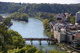
Kapuzinerinsel, in front of it the Wasserburger Innbrücke.

The island with a sandy beach in spring.


.jpg)
Individual evidence
- ^ BayernAtlas. Retrieved March 16, 2018 .
- ↑ Reinhold Lehmann, Kathrin Schön: GeoWandern Münchner Umland: Alpine foothills and Alps between Lech and Inn. 40 tours. With GPS tracks . Bergverlag Rother GmbH, 2017, ISBN 978-3-7633-3156-7 , p. 255 ( google.de [accessed on March 14, 2018]).
- ↑ Julia Lorenzer, Fabian Marcher: 111 places in Rosenheim and the Inn Valley that you have to see: travel guides . Emons Verlag, 2016, ISBN 978-3-86358-929-5 ( google.de [accessed on March 14, 2018]).
- ↑ Habitat for the grayling. In: OVB online. March 17, 2010, accessed March 18, 2018 .
- ↑ Show the direction of the Inn. In: OVB online. March 4, 2009, accessed March 18, 2018 .
- ↑ And suddenly the jetty is completely up to date . In: https://www.wasserburg24.de . August 9, 2012 ( wasserburg24.de [accessed on March 14, 2018]).
- ↑ First doubts arise . In: https://www.wasserburg24.de . November 15, 2012 ( wasserburg24.de [accessed on March 14, 2018]).
- ↑ About the island instead of the Innwerk? In: https://www.rosenheim24.de . February 29, 2012 ( rosenheim24.de [accessed on March 14, 2018]).