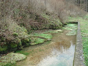
Karst spring Ehrhardsmühle
| Karst spring Ehrhardsmühle | |
|---|---|
 The karst spring behind the Ehrhardsmühle |
|
| location | |
| Country or region | District of Lichtenfels , Upper Franconia ( Bavaria ) |
| Coordinates | 50 ° 1 ′ 37 " N , 11 ° 11 ′ 37" E |
| geology | |
| Mountains | Franconian Alb |
| Source type | Karst spring |
| rock | White Jura |
| Hydrology | |
| River system | Rhine |
| Receiving waters | Ehrhardsmühlbach → Weismain → Main → Rhine → North Sea |
Coordinates: 50 ° 1 ′ 37 ″ N , 11 ° 11 ′ 37 ″ E
The karst spring Ehrhardsmühle is a karst spring designated as a natural monument near Kleinziegenfeld in Upper Franconia .
description
The source is behind the Erhardsmühle in a side valley of the Weismain towards Großziegenfeld . In an enclosed spring basin, several karst springs arise directly from the mountainside of the Upper Jura . The outflowing Ehrhardsmühlbach is dammed by a weir and was used to operate the mill. After about 300 meters it joins the Weismain.
The karst spring has been designated as a valuable geotope by the Bavarian State Office for the Environment (geotope number: 478Q002).
See also
Web links
Commons : Karstquelle Ehrhardsmühle - Collection of images, videos and audio files
Individual evidence
- ↑ Map series of the BayernAtlas
- ↑ Google Earth
- ^ Bavarian State Office for the Environment, Geotope Karstquelle E von Großziegenfeld (accessed on October 14, 2017).