Map orientation
The map orientation describes which direction is “up” on the geographic map. Modern maps are mostly oriented to the north. The orientation can be recognized by a north arrow or a compass rose . Locations are usually labeled horizontally, regardless of the map orientation. The labeling of roads, rivers or mountain ridges follows their course. The name of the map orientation is mostly in English .
North-up

With “North-up”, north is at the top of the map. Modern maps are mostly oriented to the north. The circles of longitude (meridians) run more or less vertically from top to bottom, and the circles of latitude more or less horizontally from left to right, depending on the depiction of the globe on the paper surface ( map projection ). The labeling corresponds to the usual reading direction from left to right, i.e. from west to east. The card always keeps the same position.
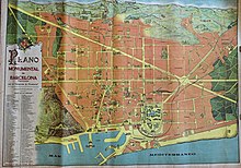
The northing of maps did not become a convention until the 19th century. Medieval maps often faces east (the Orient facing → orient ated). With the start of the systematic survey , maps are often south-wedged , but sometimes local geographic conditions also specify an orientation, e.g. B. a coastline or mountain line. Even modern city maps of Barcelona are usually oriented to the north-west because of the diagonal road grid, the mountain and coastline.
Course-up
With "Course-up" the map is aligned so that the course to be driven is on top of the map. The course is the straight line direction from start to destination. So the destination is on top of the map. The advantage is that the goal is always on top, even when changing course. As a result, the map always keeps the same position over a route. And if the direction of travel coincides with the course, you will see the same thing on the map as if you look ahead out of the window. The disadvantage is that when you change course, the map no longer matches the view ahead.
Course-up requires data on the direction to the destination in electronic form, which is then used to control the orientation of the map.
Head up
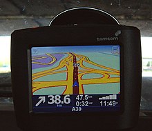
With “Head-up”, the non-stabilized (see: Course-Up / North-up ) heading points towards the top of the screen. The card is oriented in the direction of movement. As soon as the vehicle changes direction, the map rotates accordingly. The advantage is that you see exactly the same on the map as if you look out the window in front of you. As a disadvantage, the map rotates back and forth with every change of direction and is therefore very restless and difficult to read.
"Head-up" requires course data in electronic form, with which the alignment of the map is then controlled.
Car navigation devices often use "heads up" and can therefore show a "motorway view". Radar devices on ships rarely use the "head-up" display as this is not stabilized and the echoes on the screen are therefore blurred with every movement of the ship.
The "head-up" map orientation should not be confused with the head-up display , in which z. B. Pilots important information is projected into their field of vision (see also: Augmented Reality ).
Combination of head-up and course-up
Hikers with paper maps often use a mix between “head-up” and “course-up”. To do this, turn the map so that the path is oriented in the walking direction, roughly facing the goal.
Modern navigation devices use "head-up" and at the same time show the "direction to the destination as the crow flies" (course) as an arrow. This then rotates with the map, for example at a 270 ° motorway junction , and thus offers a visual check of the correctness of the route taken.
Different orientation
Special maps are often aligned with the object to be displayed. For example, if a river or canal runs northeast to southwest, then on a north-facing map, it runs diagonally from top right to bottom left. A map could also be drawn so that the flow line is shown horizontally. The top would then be northwest, so the map would then be oriented to the northwest. An example is the historical map of the Kiel Canal .
Plans of buildings are usually oriented in such a way that their walls appear vertically and horizontally on the plan. A north arrow is added to identify the orientation.
Geographically and magnetically north
The map orientation always refers to the geographic North Pole . However, the compass reacts to magnetic fields and shows the direction to the magnetic south pole . This deviation is called the declination . Depending on the area, these deviations vary in size and change over the years. These deviations and their changes are also noted on nautical charts .


