
Karumsee
| Karumsee | ||
|---|---|---|

|
||
| Geographical location |
|
|
| Drain | drainless | |
| Islands | 3 | |
| Data | ||
| Coordinates | 14 ° 1 ′ N , 40 ° 24 ′ E | |
|
||
| Depth below sea level | 123 m below sea level | |
| surface | 50 km² | |
| length | 18 km | |
| width | 5 km | |
|
particularities |
||

The Karumsee (also Assala) is a lake in the Afar region at the deepest point of Ethiopia in the Koba Depression .
location
The lake, which is elongated in north-south direction, is one of three salt lakes in the north of the Danakil Depression, next to the neighboring Lake Bakili and Lake Afrera . It is 123 m below mean sea level . The lake is on a line with the somewhat smaller Bakili lake to the south-east between the Erta Ale (south-east) and the Dallol (north-west). In the northern third of the lake there are three islands, one of which is called Maraho Karum .
The former mining settlement Dallol is located north of Lake Karum. The lake is extremely salty and is surrounded by a salt pan that is still mined today. The salt is transported to the rest of the country by caravans .
gallery

The Bakili (green center) with the Karum in the north and the slopes of the Erta Ale in the south

Salt pan on the Karumsee

Salt production at the Karumsee

Camel caravan for the removal of the salt plates
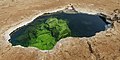
A hole in the salt pan with visible water from the Karumsee


