Kashan (Murgab)
|
Kashan Kash |
||
|
|
||
| Data | ||
| location |
Badghis ( Afghanistan ), Mary ( Turkmenistan ) |
|
| River system | Murgab | |
| Drain over | Murgab → Karakum Desert | |
| source | Northern flank of Selseleh-ye Safīd Kūh 34 ° 35 ′ 37 ″ N , 63 ° 36 ′ 17 ″ E |
|
| muzzle | at Tagtabazar in the Murgab Coordinates: 35 ° 56 ′ 1 ″ N , 62 ° 58 ′ 33 ″ E 35 ° 56 ′ 1 ″ N , 62 ° 58 ′ 33 ″ E
|
|
| length | 252 km | |
| Catchment area | approx. 7000 km² | |
| Discharge at the Babulai A Eo gauge : 5265 km² |
MQ 1974/1978 Mq 1974/1978 |
2.68 m³ / s 0.5 l / (s km²) |
| Outflow location: 4 km above the mouth |
MNQ |
1.4 m³ / s |
| Small towns | Tag tabazar | |
| Communities | Qadis | |
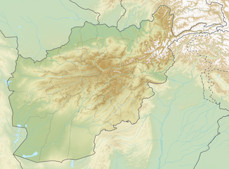
Relief map of Afghanistan with the source and mouth of the Kashan |
The Kaschan (also Kasch ) is a left tributary of the Murgab in Afghanistan and Turkmenistan ( Central Asia ).
course
It originates in the Badghis province in northwest Afghanistan on the northern flank of Selseleh-ye Safīd Kūh (ancient name: Paropamisus ). It flows mainly north to Turkmenistan and flows into the Murgab at Tagtabazar .
The Kashan has a length of 252 km. It drains an area of approximately 7000 km². The river is mainly fed by the snowmelt and carries the largest amounts of water in March. The mean discharge 4 km above the estuary is 1.4 m² / s. Some of the river water is diverted for irrigation purposes . The river usually dries up between June and October.
Hydrometry
Average monthly discharge of the Kashan (in m³ / s) at the Babulai gauge
measured from 1974 to 1978

Individual evidence
- ↑ a b c d e Article Kashan in the Great Soviet Encyclopedia (BSE) , 3rd edition 1969–1978 (Russian)
- ↑ a b Streamflow Characteristics at Streamgages in Northern Afghanistan and Selected Locations (PDF 5.6 MB) USGS.
