
Kayak Island
| Kayak Island | ||
|---|---|---|
 |
||
| Waters | Pacific Ocean | |
| Geographical location | 59 ° 56 ′ N , 144 ° 22 ′ W | |
|
||
| length | 32 km | |
| width | 3 km | |
| surface | 73.7 km² | |
| Residents | uninhabited | |

The Island Kayak Iceland , formerly St. Elias, in the Gulf of Alaska is located about 100 km southeast of Cordova . It has an area of 73.7 km² and is uninhabited.
The island was discovered by Vitus Bering in 1741 as part of his Second Kamchatka Expedition , but it was believed to be a peninsula of Alaska . Lieutenant Sarichef of the Russian Navy named the island Kayak in 1826 because of its shape reminiscent of Eskimos kayaks.
On July 30, 1741 (St. Elias Day), the German naturalist and physician Georg Wilhelm Steller , a member of Vitus Bering's Second Kamchatka Expedition, was the first European naturalist to go ashore for 10 hours, which is enough for him, around 160 Document plant species. He also discovered a depot of the Aleutians who lived there and removed a number of everyday objects and jewelry for his ethnological collection. Captain James Cook landed here on May 12, 1778.
Cape Saint Elias is located at the southwest end of the island. The mountain Mount Saint Elias was probably named after the Cape.
The Lighthouse Cape St. Elias Light is an important navigational aid for the maritime surrounding the island.
The landing site of Vitus Bering under the name Expedition Landing Site Bering since July 20, 1977 as a historic site in the National Register of Historic Places lists. On June 2, 1978, it was recognized as a National Historic Landmark .
Picture gallery
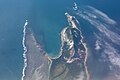
Aerial view of Cape St. Elias and Pinnacle Rock (top right) (2010)

Prince William Sound (2013)

Bering Expedition Landing Site (2013)
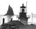
Cape St. Elias Lighthouse (2013)


.jpg)

Web links
Individual evidence
- ↑ Bering Expedition Landing Site on the National Register Information System. National Park Service , accessed July 27, 2017
- ↑ Listing of National Historic Landmarks by State: Alaska. National Park Service , accessed July 20, 2019.