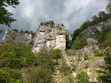
Kanzianiberg climbing garden
The Kanzianiberg climbing garden is one of the largest and oldest climbing areas in Austria .
The monolithic lime conglomerate floor on the southwest side of the Kanzianiberg , an elevation in front of the Karawanken north, is located in the municipality of Finkenstein am Faaker See , Villach-Land district , Carinthia . A more than 700 m long wall flight with wall heights between six and seventy meters offers over 500 sport climbing routes (2013) of all levels of difficulty. The mostly vertical or slightly overhanging walls are well insured with bolts, chain stands and carabiners. There are also numerous via ferratas (see; Kanzianiberg via ferrata ) as viewing and family trails as well as to reach climbing routes. There are several exercise and bouldering rocks at the foot of the climbing walls .
The area was developed as a climbing garden in the 1970s. The Association of Austrian Mountain and Ski Guides, Section Carinthia, with the support of the Österreichische Draukraftwerke AG and the Office of the Carinthian Provincial Government, has opened the first climbing garden in Carinthia, which was also one of the most beautiful climbing areas in the German-speaking area. In 1979 there were only 32 climbing routes and 6 secured via ferrata with 416 hooks and anchors and 650 meters of steel cable. Klaus Hoi and Hias Kumnig particularly excelled at the development, the latter is commemorated by a plaque in the area of the information hut.
Since almost every climbing situation can be practiced, the rocks also serve as a practice and training area for aid and rescue organizations.
literature
- Guide through the Finkenstein-Kanzianiberg climbing garden by Alarich Warmuth (1987)
- Climbing in Carinthia and East Tyrol by Ingo Neumann, 2nd edition (2007)
- Climbing on Kanzianiberg by Ingo Neumann, 7th edition (2013)
- Austria Vertical - Sport Climbing in Austria by Timo Marschner and Martin Schepers, 4th edition (2007)
- Via ferrata guide Austria by Axel Jentzsch-Rabl, Andreas Jentzsch and Dieter Wissekal, 5th edition (2013)
- Via ferrata atlas Alps by Paul Werner and Iris Kürschner, 7th edition (2012)
- Der Bergsteiger , November 1979 edition, p. 650
Websites
Individual evidence
Coordinates: 46 ° 33 '7.9 " N , 13 ° 52' 22.4" E
