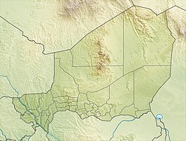
Kokorou Namga Complex
|
Kokorou-Namga Complex
Complexe Kokorou-Namga |
||
| location | Téra department , Tillabéri region , Niger | |
| surface | 668.29 km² | |
| Geographical location | 14 ° 12 ' N , 0 ° 56' E | |
|
|
||
| Setup date | June 17, 2001 | |
The Kokorou-Namga Complex ( French : Complexe Kokorou-Namga ) is a wetland in the Téra department in western Niger . It is protected under the Ramsar Convention .
Location and characteristics
The Kokorou Namga Complex is predominantly located in the Kokorou Municipality area . The south-western part is in the municipality of Téra . Both communes belong to the department of Téra in the Tillabéri region .
The protected area is in the shape of a rectangle and extends over an area of 66,829 hectares . The entry as Ramsar area took place on June 17, 2001. The lakes Mare de Kokorou and Mare de Namga and several intermittent ponds are located in the Kokorou-Namga complex . The waters are separated from each other by strip-shaped dune landscapes. They create a microclimate that dampens the hot and dry climate of the Sahel zone . The groundwater is unsteady and is relatively deep, about 30 meters below the surface of the earth.
The Kokorou-Namga complex is the home or wintering place of numerous water birds. A census in 2000 showed almost 50,000 individual animals from 56 species. These include endangered species such as the crowned crane , the pond rail and the purple grouse . The widow whistling goose , the yellow whistling goose and the humped goose are particularly well represented . The vegetation on the ferrous soils is comparatively dense around the lakes. There, in the flooded areas, a forest savannah was created. Anabrees and desert dates thrive on the plateaus and in millet fields near the waters . Seyal acacias and Anogeissus leiocarpa can be found in dry stream beds and other lowlands .
The lakes and ponds are at risk from erosion and pollution as a result of household water use. Other threats to the area include overgrazing , overhunting and overuse of plants for medicinal purposes. The harvest of wood , which is needed as building material and firewood, increased sharply due to the emergence of the nearby mining town of Komabangou .
Settlements
The largest settlements in the protected area are (in brackets the population figures from the 2012 census):
- the village of Kokorou (2919 inhabitants),
- the village of Doungourou (2577 inhabitants),
- the hamlet of Sébangou (1972 inhabitants),
- the village of Namga (1440 inhabitants),
- the hamlet of Darabangou (1252 inhabitants),
- the village of Zoribi (1222 inhabitants),
- the village of Fonéko Tédjo (1110 inhabitants),
- the hamlet of Toussoukokorou (1016 inhabitants).
See also
literature
- Issoufou Adamou: Contribution à l'élaboration d'un système d'inventaire et de surveillance des zones humides. Cas du complexe de Namga Kokorou (département de Téra) . Faculté d'Agronomie, Université Abdou Moumouni de Niamey, Niamey 2009.
- Hassane Saley Moussa: Identification des actions prioritaires pour la protection et la gestion durable des ressources naturelles du complexe de Namga Kokorou (département de Téra) . Faculté d'Agronomie, Université Abdou Moumouni de Niamey, Niamey 2009.
Web links
- Kokorou-Namga Complexes. In: Ramsar Sites Information Service. April 13, 2018(English).
Individual evidence
- ^ Système de zones humides du complexe Kokorou-Zorobi-Namaga-Tida, Arrondissement de Téra, Canton de Kokorou. (PDF) map. Direction de la Faune, de la Pêche et de la Pisciculture, April 2001, accessed on March 10, 2019 (French).
- ↑ a b National Repertoire des Localités (ReNaLoc). (RAR; 11.3 MB) Institut National de la Statistique de la République du Niger, July 2014, pp. 506, 508–510, 513 , accessed on August 7, 2015 (French).
- ↑ a b Kokorou-Namga Complexes. In: Ramsar Sites Information Service. April 13, 2018, accessed March 10, 2019 .
- ↑ a b c Kokorou-Namga Complex. Ramsar Information Sheet (RIS). (PDF) In: Ramsar Sites Information Service. August 30, 2000, pp. 1–2 , accessed March 10, 2019 (English).
- ↑ a b Kokorou-Namga Complex. Ramsar Information Sheet (RIS). (PDF) In: Ramsar Sites Information Service. August 30, 2000, pp. 3–4 , accessed on March 10, 2019 (English).
- ↑ Kokorou-Namga Complex. Ramsar Information Sheet (RIS). (PDF) In: Ramsar Sites Information Service. August 30, 2000, pp. 5-6 , accessed March 10, 2019 (English).
