Kolvitsa (river)
|
Kolwiza Колвица |
||
| Data | ||
| Water code | RU : 02020000212101000009428 | |
| location | Murmansk Oblast ( Russia ) | |
| River system | Kolvitsa | |
| origin | See Lake Kolvitskoye 67 ° 4 '53 " N , 33 ° 10' 52" O |
|
| Source height | 58 m | |
| muzzle | to Kandalaksha Bay ( White Sea ) Coordinates: 67 ° 5 ′ 0 ″ N , 32 ° 58 ′ 49 ″ E 67 ° 5 ′ 0 ″ N , 32 ° 58 ′ 49 ″ E |
|
| Mouth height | 0 m | |
| Height difference | 58 m | |
| Bottom slope | 6.4 ‰ | |
| length | 9 km | |
| Catchment area | 1310 km² | |
| Discharge at the Kolwiza A Eo gauge : 1260 km² Location: 4.3 km above the mouth |
MQ 1928/1992 Mq 1928/1992 |
14.8 m³ / s 11.7 l / (s km²) |
| Communities | Kolvitsa | |
|
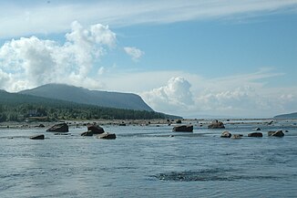
The Kolvitsa River at its mouth |
||
The Kolwiza ( Russian Колвица ) is a 9 km long river in the southwest of the Kola Peninsula in the Murmansk Oblast in Russia .
The catchment area covers 1310 km², the mean discharge is 14.7 m³ / s. The Kolwiza forms the outflow of the 58 m high and 121 km² large Kolwizkoje Lake, flows in a westerly direction and flows into an eastern branch of the Kandalaksha Bay and thus into the White Sea at the settlement of the same name .
Web links
Commons : Kolwiza - collection of pictures, videos and audio files
Individual evidence
- ↑ a b Kolwiza at the Kolwiza gauge - 4.3 km - hydrographic data at R-ArcticNET (engl.)
- ↑ a b Kolwiza in the State Water Register of the Russian Federation (Russian)

