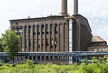
Kopalnia Węgla Kamiennego Jowisz
The coal mine Jowisz (Polish Kopalnia Węgla Kamiennego. Jowisz ; German name Jupiter ) is a disused coal mine in the Silesian Wojkowice , Poland.
history
The Jupiter / Jowisz colliery was founded by textile entrepreneurs from Łódź , who already successfully operated the neighboring Saturn mine . This company was later called "Union Saturn" ( Towarzystwo Saturn ). Initially, money was only made available to purchase the rights holders . In the years 1902–1907 the Polish mining engineer Henry Czeczot carried out test drillings in the area of the village Wojkowice and confirmed the existence of coal deposits.
In 1907 the sinking of the shafts "Karol" ( shaft diameter 5.5 m) and "Edward" (6.5 m) began. The opening took place in 1910 and two years later, on November 26, 1912, the first ton of coal was mined . During the First World War, German troops destroyed the access facilities in 1914; nevertheless, production could be resumed after four months.
As part of modernization measures, conveyor belts were used in the daytime facilities . A sorting system was set up in 1915–1917 and the mine was connected to the Grodziec station by a standard-gauge railway line. This enabled the mine to become a market leader in the industrial area of Upper Silesia in 1918 with around 150,000 t of coal. The global economic crisis did not stop at the Jowisz CHP either. There was short-time work and massive job cuts . In order to avoid economic hardship, coal was illegally mined in several places in the opencast mine .
During the Second World War (from the end of 1941) the mine was taken over by Preussag and the name of the mine was changed to Jupiter . In addition to prisoners of war, miners from Italy were also employed.
After the war the mine was nationalized and integrated into the coal industry association of Dombrowa in Sosnowiec. In addition to the two shafts "Edward" and "Karol", it also had the outdoor facilities "Alfred" and "Alfons". A massive mechanization of coal mining enabled an annual production of more than one million tons of coal to be achieved from 1951.
In the 1990s there were numerous upheavals in the organizational and operational structure.
- The Zakład Górniczy "Wojkowice" Sp. Z oo business with 1,200 employees, a coal mining on the area of 4.3 square kilometers.
- The thermal and electrical power plant was operated by "Wojzec" Sp. Z oo .
- There were also trading and service companies, one of which had the task of promoting the liquidation of the mine.
The fact that the privately operated trade union “Wojkowice” was unsuccessful is mainly due to the fact that the seam “620”, which had recently been developed, did not allow mining on a broad front due to numerous geological faults . Important safety pillars also had to be left in place for reasons of flood protection for the Brynica and Jaworznik streams . The last ton of coal was mined in 2000 and the mine closed six years later. 531 employees, d. H. 47% of the workforce found continued employment in the neighboring mines.
Funding figures
1913: 19,520 t; 1938: 496,214 t; 1970: 1.79 million t; 1979: 1.97 million t
annotation
- ↑ The presentation of the history of this mine is largely based on the Internet presentation http://wojkowice.pl/index.php/dzieje-przemyslu (accessed on February 21, 2016)
swell
- Jerzy Jaros. Słownik historyczny kopalń węgla na ziemiach polskich . Katowice 1984. ISBN 83-00-00648-6
- Yearbook for the Upper Mining District Wroclaw . Phoenix Publishing House. Katowice, Breslau, Berlin. 1913. Digitized version at http://www.dbc.wroc.pl/dlibra/publication?id=3349&tab=3 before (last accessed on May 5, 2015)
- Kurt Koenig. Coal mining in Upper Silesia from 1945–1955 . Scientific contributions to the history and regional studies of Eastern Central Europe. Published by the Johann Gottfried Herder Institute. Marburg 1958.
- For the history of the mine, see the website http://wojkowice.pl/index.php/dzieje-przemyslu (accessed on February 21, 2016).
Coordinates: 50 ° 21 ′ 20.9 ″ N , 19 ° 2 ′ 53.5 ″ E


