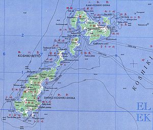
Koshikijima Islands
| Koshikijima Islands | ||
|---|---|---|
| topographic map of the islands | ||
| Waters | East China Sea | |
| Geographical location | 31 ° 46 ′ N , 129 ° 48 ′ E | |
|
|
||
| Number of islands | 3 larger, various smaller ones | |
| Total land area | 118.68 km² | |
| Residents | 5576 (2010) | |
The Koshikijima Islands ( Japanese 甑 島 列島 , Koshikijima-rettō ) or Koshiki Islands ( 甑 列島 , Koshiki-rettō ) are a chain of islands belonging to Japan in the East China Sea , a little more than 20 km west of Kyūshū . Administratively, the islands belong to the municipality of Satsumasendai . However, ferry connections only exist to and from Ichiki-Kushikino .
Islands
The archipelago consists of three larger islands and some smaller ones, especially in the north. These are:
| Surname | Japanese | Area [km²] | Height [m] | Coordinates |
|---|---|---|---|---|
| Kami-Koshikijima | 上 甑 島 | 45.08 | 423.3 | 31 ° 51 ' N , 129 ° 53' E |
| Naka-Koshikijima | 中 甑 島 | 7.29 | 296 | 31 ° 47 ′ 55 " N , 129 ° 49 ′ 39" E |
| Shimo Koshikijima | 下 甑 島 | 66.27 | 603.6 | 31 ° 42 ' N , 129 ° 44' E |
| Benkeijima | 弁 慶 島 | ? | 31 ° 46 ′ 23 " N , 129 ° 49 ′ 56" E | |
| Chikajima | 近 島 | 92.5 | 31 ° 51 ′ 4 ″ N , 129 ° 57 ′ 2 ″ E | |
| Futagojima | 双子 島 | 62.2 | 31 ° 51 ′ 44 " N , 129 ° 58 ′ 36" E | |
| Inujima | 犬 島 | 6.0 | 31 ° 52 ′ 28 " N , 129 ° 57 ′ 14" E | |
| Kaseto | 筒 島 | 31 | 31 ° 52 ′ 1 ″ N , 129 ° 57 ′ 12 ″ E | |
| Kojima | 小島 | ? | 31 ° 49 ′ 0 ″ N , 129 ° 51 ′ 41 ″ E | |
| Kojima | 小島 | 31 | 31 ° 48 ′ 52 " N , 129 ° 54 ′ 11" E | |
| Nakajima | 中 島 | 112.8 | 31 ° 49 ′ 34 " N , 129 ° 50 ′ 28" E | |
| Nojima | 野 島 | 97.8 | 31 ° 51 ′ 57 " N , 129 ° 57 ′ 38" E | |
| Oki-no-shima | 沖 の 島 | 48 | 31 ° 51 '53 " N , 129 ° 59' 3" E | |
| Yurajima | 由 良 島 | 42 | 31 ° 44 ′ 35 " N , 129 ° 45 ′ 19" E | |
|
|
||||
history
The archipelago is first mentioned in Shoku Nihongi , when the ruler of the Hayato 769 who lived there was given court rank . In 1889 the eight villages on the northern main island of Kami-Koshikijima (including Naka-Koshikijima) and the six villages on the southern main island of Shimo-Koshikijima were merged to form the two villages of the same name. In 1891 the eastern district of Sato ( 里 (村) ) was spun off again from Kami-Koshikijima and in 1949 the northern district of Imuta ( 藺 牟 田 ) from Shimo-Kishikijima as Kashima ( 鹿島 村 ). In 2004 all four villages, together with Sendai , Hiwaki , Iriki , Tōgō and Kedōin , were merged to form the new community Satsumasendai .
Culture
On the island of Shimo-Koshikijima, the New Year's ceremony Koshikijima no Toshidon ( 甑 Insel の ト シ ド zu ) takes place, in which adults dressed up like demons go from house to house as a child horror figure to scold the children for their wrongdoings and preach good behavior. When they say goodbye, they give the children mochi . This custom was included in the list of masterpieces of the oral and intangible heritage of humanity by UNESCO in 2009 .
Individual evidence
- ↑ a b c d e 甑 島 地域 離島 振興 計画 (“ Funding plan for remote islands in the Koshikijima region”). (PDF; 558 kB) Kagoshima Prefecture, accessed on August 3, 2016 (Japanese).
- ↑ Heights and coordinates according to the official topographic map
- ↑ 弁 慶 島 (上 甑 島) . In: koshikijima.net. 甑 島 観 光 協会 , accessed September 29, 2012 (Japanese).
- ↑ 近 島 (里 村) . In: koshikijima.net. 甑 島 観 光 協会 , accessed September 29, 2012 (Japanese).
- ↑ 双子 島 (里 村) . In: koshikijima.net. 甑 島 観 光 協会 , accessed September 29, 2012 (Japanese).
- ↑ a b c 野 島 ・ 筒 島 ・ 犬 島 (里 村) . In: koshikijima.net. 甑 島 観 光 協会 , accessed September 29, 2012 (Japanese).
- ↑ 小島 ・ 小 ヶ 倉 鼻 (里 村) . In: koshikijima.net. 甑 島 観 光 協会 , accessed September 29, 2012 (Japanese).
- ↑ 沖 の 島 (里 村) . In: koshikijima.net. 甑 島 観 光 協会 , accessed September 29, 2012 (Japanese).
- ↑ 由 良 島 ・ ダ ン ガ イ 島 (鹿島 村) . In: koshikijima.net. 甑 島 観 光 協会 , accessed September 29, 2012 (Japanese).
- ↑ 歴 史 概要 . In: koshikijima.net. 甑 島 観 光 協会 , accessed September 29, 2012 (Japanese).
- ↑ Koshikijima no Toshidon. UNESCO, accessed on October 19, 2018 .


